
 English
 Français

Malton Museum
Malton Museum is an archaeological museum based in Malton, North Yorkshire.
Nearby Places View Menu
130 m
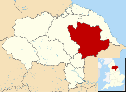
Ryedale District
Ryedale was a non-metropolitan district in North Yorkshire, England. It was in the Vale of Pickering, a low-lying flat area of land drained by the River Derwent. The Vale's landscape is rural with scattered villages and towns. It has been inhabited continuously from the Mesolithic period. The economy was largely agricultural with light industry and tourism playing an increasing role.
Towns included Helmsley, Kirkbymoorside, Malton, Norton-on-Derwent, and Pickering. Part of Ryedale lies within the North York Moors National Park. The A64 passed through Ryedale and villages such as Rillington. In the 2011 Census, the population of this primarily rural area of 150,659 hectares, the largest district in North Yorkshire, was 51,700.

130 m
Ryedale (UK Parliament constituency)
Ryedale was a constituency in North Yorkshire represented in the House of Commons of the Parliament of the United Kingdom. It elected one Member of Parliament (MP) by the first past the post system of election. It was created in 1983 and abolished in 2010.

331 m
Derventio Brigantum
Derventio, sometimes described as Derventio Brigantium (Latin for "Derventio of the Brigantes") in order to distinguish it from other places called Derventio, was a Roman fort and settlement located beneath the modern town of Malton in North Yorkshire, England. The fort is 18 miles north-east of Eboracum on the River Derwent.

380 m
Malton Quaker Meeting House
Malton Quaker Meeting House is a historic building in Malton, North Yorkshire, a town in England.
The first Quaker meeting in Malton took place in 1671, and in 1677 a small thatched meeting house was constructed on Spital Hill. During the 18th century, a burial ground was created on Greengate, and between 1820 and 1823 a new meeting house was constructed on part of the burial ground. The building was grade II* listed in 1951. In the 1980s, there was a proposal to demolish the building, but it was instead restored from 1991 to 1993, using a grant from English Heritage.
The building is constructed of pink and cream mottled brick on a sandstone plinth, with sandstone dressings, a sill band, a moulded eaves cornice, and a hipped slate roof. There is one tall storey and six bays. On the front is a doorway, above which is a blocked square opening. The windows are sashes, and all the openings have flat arches of gauged brick. Inside, there are two meeting rooms, with a through passage between them. There is a painted timber dado in both rooms, and in the larger rooms there is a timber elder's stand at the west end. The walls enclosing the burial ground are in brick with flat stone coping, some sections dating from the 18th century.
The neighbouring caretaker's house also dates from 1823, and is grade II listed. The house is built of pink and cream mottled brick, with an eaves band and slate roof. There are two storeys, one bay facing the road, and two bays on the left return. The windows are sashes with cambered arches. In the left return is a doorway with a cambered head, and an upper floor extension on posts.