
 English
 Français

Unthank, Derbyshire
Unthank is a hamlet in the North East Derbyshire district of Derbyshire, England. It is sited on a narrow lane on the southern slopes of the Cordwell Valley, at an altitude of about 185 metres (610 ft). On 6 May 1970, a USAF McDonnell-Douglas RF-4C crashed in the nearby Stripes Wood while doing a NATO training exercise. Both crew men ejected and landed at Curbar Edge.
Nearby Places View Menu

1.5 km
Barlow Woodseats Hall
Barlow Woodseats Hall is a Grade II* listed manor house situated at Barlow Woodseats, on the edge of the village of Barlow, in Derbyshire. It remains the only manor house in the Parish of Barlow, and the current house dates from the early 17th century, although there are much earlier origins to before 1269.
2.1 km
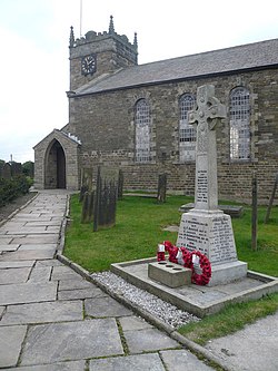
St Swithin's Church, Holmesfield
St Swithin's Church is a Grade II listed parish church in the Church of England in Holmesfield, Derbyshire.

2.1 km
Holmesfield
Holmesfield is a village and civil parish in the English county of Derbyshire. The population of the civil parish at the 2011 census was 971. The name "Holmesfield" means "raised pasture-land" and is of Norse and Anglo-Saxon origin. Viking influences are also evident with many road names suffixed by "gate", the old Norse word for "way".
2.2 km
Cartledge
Cartledge is a hamlet in Derbyshire, England. It is 10 kilometres (6 mi) southwest of Sheffield, and just south of the village of Holmesfield. Its name is derived from the Old Norse kartr, meaning rocky ground, and the Old English pre 7th-century loecc, meaning boggy stream. It features Cartledge Hall, which was built c.1492 by John Wolstenholme and later rebuilt during Elizabethan times.