
 English
 Français
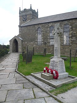
St Swithin's Church, Holmesfield
St Swithin's Church is a Grade II listed parish church in the Church of England in Holmesfield, Derbyshire.
Nearby Places View Menu

188 m
Holmesfield
Holmesfield is a village and civil parish in the English county of Derbyshire. The population of the civil parish at the 2011 census was 971. The name "Holmesfield" means "raised pasture-land" and is of Norse and Anglo-Saxon origin. Viking influences are also evident with many road names suffixed by "gate", the old Norse word for "way".
506 m
Cartledge
Cartledge is a hamlet in Derbyshire, England. It is 10 kilometres (6 mi) southwest of Sheffield, and just south of the village of Holmesfield. Its name is derived from the Old Norse kartr, meaning rocky ground, and the Old English pre 7th-century loecc, meaning boggy stream. It features Cartledge Hall, which was built c.1492 by John Wolstenholme and later rebuilt during Elizabethan times.

1.5 km
Dronfield Woodhouse
Dronfield Woodhouse is a district of Dronfield, in the North East Derbyshire district, in the county of Derbyshire, England. The area has been inhabited since at least the 11th century (Cowley – pronounced Coaley – Farm, to the south) and its main road, Carr Lane, features a 13th-century house, formerly Hall Farm. The 19th-century former primary school on Holmesfield Road is now an elderly care home.
Coal mining was an important activity in the village in the 19th and early 20th centuries and the last pit to close was Hurst Hollow in 1947. The current public house, the Miners' Arms, stands opposite the entrance to one of the former mines. Along with mining went Methodism. The chapel, built in 1848, has recently been converted into a dwelling following its closure. In the immediate post-war period the village had its own post office and general store opposite Hall Farm and there were also two other village shops in Carr Lane. The building of a number of council houses in the 1950s linked Dronfield Woodhouse to the hamlet of Stubley, which in its turn had already been joined to Dronfield in the period between the two world wars. In the 1960s a large housing development took place in the adjacent Gosforth Valley turning Dronfield Woodhouse into a quiet dormitory settlement for nearby Sheffield and Chesterfield. The surrounding countryside is still readily accessible, however, and the boundary of the Peak District National Park is less than 2 miles to the west.
On 31 December 1894 Dronfield Woodhouse became a separate civil parish, being formed from Dronfield, on 1 April 1935 the parish was abolished and merged with Dronfield. In 1931 the parish had a population of 976.
1.9 km
Totley Brook
The Totley Brook is a stream in Sheffield, South Yorkshire, England. It rises on a millstone grit ridge some 7 miles (11 km) to the south-west of the centre of Sheffield. Over its course it drops from 740 feet (230 m) to 430 feet (130 m) near its junction with the Old Hay Brook close to Baslow Road. The streams form the River Sheaf once they have joined.
There is an estate in Dore called Totley Brook, despite the fact that it is actually situated on the Old Hay Brook.
The Totley Brook runs around the south of Totley through Gillfield Woods, flows underneath Mickley Lane, behind the Totley Rise shops and meets Old Hay behind Milldale where Totley Chemical Works once stood. The Works was run by Tinker and Siddall from 1846, and had been taken over by Thomas Kilner by 1899, who manufactured pyroligneous acid, naptha and charcoal.
In September 2014 Sheffield City Council announced plans to create a flood alleviation programme on the Totley Brook. It would consist of an embankment to create a temporary flood storage upstream of Totley. It is estimated that the facility would reduce the depth of water downstream in the River Sheaf by 10 inches (0.26 m) during periods of heavy rainfall.