Location Image

Shuttleworth, Greater Manchester

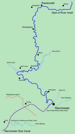
Shuttleworth is a hamlet at the northeastern extremity of the Metropolitan Borough of Bury, in Greater Manchester, England. It lies amongst the South Pennines, 4.3 miles (6.9 km) north of Bury and 0.9 miles (1.4 km) south of Edenfield; Scout Moor Wind Farm lies to the immediate east. Effectively a suburb of Ramsbottom, the M66 motorway divides Shuttleworth from the main core of that town. Historically a part of Lancashire, the name Shuttleworth derives from the Old English scyttels and worth meaning a gated enclosure. The first element refers to a bar. It was documented as Suttelsworth in 1227 and Shuttelesworthe in 1296. From the Middle Ages, Shuttleworth lay within the township of Walmersley (sometimes called Walmersley-cum-Shuttleworth) in the ancient parish of Bury, and hundred of Salford. Walmersley-cum-Shuttleworth was made a civil parish in 1866. From 1883 the Shuttleworth area was administered as part the local government district of Ramsbottom, with the parish boundary between Walmersley-cum-Shuttleworth and Ramsbottom being adjusted to match the local government district boundary in 1894. Shuttleworth is bounded to the south by Holcombe Brook and Summerseat; to the north by Edenfield, Irwell Vale; to the west by Holcombe and Ramsbottom and to the east by Stubbins, Turn Village and Shuttleworth-cum-Turn. In the 1990s, Manchester drag queen Foo Foo Lammar lived in Shuttleworth.

Nearby Places View Menu
Location Image
845 m

Turn Village

Turn Village is a hamlet in the Rossendale borough of Lancashire, England. It is located in the South Pennines, on the A680 road between Edenfield and Norden. Population details are included in Ramsbottom. The surrounding moorland is the site for Scout Moor Wind Farm, the second largest onshore wind farm in England, which remains popular with Paragliders. The village is home to Bleakholt Animal Sanctuary and the Fisherman's Retreat restaurant.
Location Image
1.3 km

Irwell Valley

The Irwell Valley in North West England extends from the Forest of Rossendale through the cities of Salford and Manchester. The River Irwell runs through the valley, along with the River Croal.
Location Image
1.4 km

Edenfield

Edenfield is a village within the Rossendale borough of Lancashire, England. Lying on the River Irwell, it is around 1.25 miles (2.0 km) north of Ramsbottom, 2.5 miles (4.0 km) south of Rawtenstall, and 6.0 miles (9.7 km) west of Norden. At the 2001 census it had a total population of 2,080, reducing to 2,053 at the 2011 census. Edenfield village centre lies at the intersection of three A roads; the A676 from Bolton, the A680 from Accrington and Rochdale and the A56 from Rawtenstall and Bury. The M66 motorway terminates its course at Edenfield, whereupon it becomes the A56 dual carriageway known as the Edenfield Bypass. The village has recently seen growth as a commuter settlement for Greater Manchester.
Location Image
1.5 km

Ramsbottom railway station

Ramsbottom railway station serves the town of Ramsbottom, in Greater Manchester, England. It is a stop on the heritage East Lancashire Railway.