
 English
 Français

Edenfield
Edenfield is a village within the Rossendale borough of Lancashire, England. Lying on the River Irwell, it is around 1.25 miles (2.0 km) north of Ramsbottom, 2.5 miles (4.0 km) south of Rawtenstall, and 6.0 miles (9.7 km) west of Norden. At the 2001 census it had a total population of 2,080, reducing to 2,053 at the 2011 census. Edenfield village centre lies at the intersection of three A roads; the A676 from Bolton, the A680 from Accrington and Rochdale and the A56 from Rawtenstall and Bury. The M66 motorway terminates its course at Edenfield, whereupon it becomes the A56 dual carriageway known as the Edenfield Bypass. The village has recently seen growth as a commuter settlement for Greater Manchester.
Nearby Places View Menu
232 m
Irwell Valley
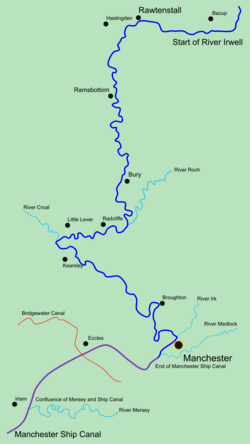
The Irwell Valley in North West England extends from the Forest of Rossendale through the cities of Salford and Manchester. The River Irwell runs through the valley, along with the River Croal.

624 m
Strongstry
Strongstry is a small hamlet in Rossendale, Lancashire, England. The hamlet is only accessible by an unadopted road running through a factory. It is accessible on several walking routes. For local government purposes, it receives services from Rossendale Borough Council and Lancashire County Council. Nearby are the village of Stubbins and the hamlet of Chatterton. The East Lancashire Railway runs through Strongstry, but there is no station there.
Much of the land to the west of the village is in the care of the National Trust and consists of hillside pasture and woodland leading up to Holcombe Moor and Peel Tower.

668 m
Chatterton, Lancashire
Chatterton is a small village in the southern part of the Rossendale Valley in the Rossendale area of Lancashire, England.
It is half a mile north of Ramsbottom town centre on the A676 between Bolton and Edenfield. For local government purposes, it receives services from Rossendale Borough Council and Lancashire County Council. Nearby are the village of Stubbins and the hamlet of Strongstry. Running alongside the village separating it from Strongstry is the River Irwell.
Much of the land to the west of the village is in the care of the National Trust and consists of hillside pasture and woodland leading up to Holcombe Moor and Peel Monument.
Parkland at Chatterton was given to the people of the district of Ramsbottom as a peace memorial by the Porritt family.

680 m
Stubbins railway station
Stubbins railway station served the village of Stubbins, in Rossendale, Lancashire, England.