
 English
 Français
Bridlington Rural District
Bridlington was a rural district in the East Riding of Yorkshire in England from 1894 to 1974. It covered a coastal area, and surrounded the municipal borough of Bridlington on its land borders. The district covered Flamborough and Flamborough Head. The district was created by the Local Government Act 1894. It picked up part of the Sherburn Rural District when that was abolished in 1935 by a County Review Order made under the Local Government Act 1929. At the same time parts of the district were transferred to Bridlington and Filey urban districts. It was abolished in 1974, under the Local Government Act 1972. The district was split between the new districts of North Wolds in Humberside and Scarborough in North Yorkshire.
Nearby Places View Menu
951 m
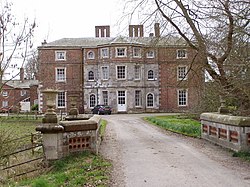
Boynton Hall
Boynton Hall is a country house in the village of Boynton near Bridlington, East Riding of Yorkshire, England. It is a Grade I listed building.
Originally constructed in the late 16th century, the house has been remodelled several times. It is built in red brick with stone dressings and a slate roof, originally to an H-shaped plan, but since infilled at the front. Originally a two-storey building, it is now a three-storey building with a 7-bay frontage. The central 5 bays project slightly and have a 3-window polygonal bay.
The Hall stands within an associated park, whose features include a walled garden and the Carnaby Temple folly (known locally as the Pepperpot). Other buildings, such as the Dairy, the Pigeon House, and the Lodge, are Grade II listed buildings.

1.2 km
Boynton, East Riding of Yorkshire
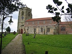
Boynton is a village and civil parish in the East Riding of Yorkshire, England. It is approximately 3 miles (5 km) west of the town of Bridlington and lies on the B1253 road.
According to the 2001 UK census, the parish had a population of 161. However the 2011 census grouped the parish with Grindale (2001 pop. 98), giving a total of 229.
The parish church of St Andrew is a Grade I listed building. It includes a 15th-century tower, as well as memorials to the
Strickland, later Cholmley, later Strickland-Constable Baronets, of Boynton (1641), whose seat was Boynton Hall, which is also Grade I listed.
The name Boynton derives from the Old English Bofaingtūn meaning 'settlement connected with Bofa'.
From the mediaeval era until the 19th century Boynton was part of Dickering Wapentake. Between 1894 and 1974 Boynton was a part of the Bridlington Rural District, in the East Riding of Yorkshire. Between 1974 and 1996 it was part of the Borough of North Wolds (later Borough of East Yorkshire), in the county of Humberside.

1.5 km
Woldgate
Woldgate is a minor road in the East Riding of Yorkshire, England, which follows the line of a Roman road. It runs for a distance of 10 miles (16 km) from a junction with the A165 on the western edge of Bridlington, through the village of Kilham, to a junction with the B1249 4 miles (6 km) north of Driffield. For most of its length Woldgate follows a low ridge of the Yorkshire Wolds, with extensive views to north and south.
The Roman road ran from the coast at Bridlington to York. Its line can be traced west from the western end of Woldgate along a series of bridleways and minor roads, and then a stretch of the A166, to Stamford Bridge, where it crossed the River Derwent by a ford.
Woldgate was the subject of a series of landscapes created in 2006 by the artist David Hockney.
National Cycle Route 1 follows the eastern part of Woldgate.
2.3 km
Carnaby, East Riding of Yorkshire
Carnaby is a small village and civil parish on the A614 road in the East Riding of Yorkshire, England. It is situated approximately 2 miles (3 km) south-west of Bridlington town centre.
The civil parish is formed by the villages of Carnaby and Haisthorpe and the hamlet of Wilsthorpe.
According to the 2011 UK Census, Carnaby parish had a population of 415, an increase on the 2001 UK Census figure of 300.
From the mediaeval era until the 19th century Carnaby was part of Dickering Wapentake. Between 1894 and 1974 Carnaby was a part of the Bridlington Rural District, in the East Riding of Yorkshire. Between 1974 and 1996 it was part of the Borough of North Wolds (later Borough of East Yorkshire), in the county of Humberside.
The name Carnaby derives from the Old Norse Kaerandibȳ or Keyrandibȳ meaning 'Kaerandi's' or 'Keyrandi's village'.
The church dedicated to St John the Baptist was designated a Grade II* listed building in 1966 and is now recorded in the National Heritage List for England, maintained by Historic England.
During the Second World War, Carnaby Aerodrome served as an emergency landing site for crippled planes. Specially built to cater for stricken aircraft, the airfield had an extra large runway, 9,000 feet (2.7 km) in length and 700 feet (210 m) wide. The airfield also operated a fog dispersion system, nicknamed FIDO.
After the war, the site was used to store Thor IRBM Missiles. The airfield finally closed in 1963 and is now an industrial estate, a large source of employment for the local area.
Carnaby railway station on the Yorkshire Coast Line from Hull to Scarborough served the village until it closed on 5 January 1970. However, people can still travel to Hull, Bridlington, Driffield and Scarborough by using the EYMS bus route number '121' that has alternative bus times.
In 1974, the Satra Motors Car Importation and Preparation Centre was opened at Carnaby, upgrading imported Russian built Lada and Moskvich cars for British showrooms. Although Moskvich had stopped importing cars to Britain by the end of the 1970s, Lada continued until July 1997, when it withdrew from Britain, sparking the closure of the Satra centre.
Carnaby Temple, an octagonal folly stands in fields about 1 mile (1.6 km) north of Carnaby. It was built by Sir George Strickland, owner of Boynton Hall, in 1770 and is locally known as 'The Pepperpot'. The structure is based on the Tower of the Winds which is on the Roman Agora in Athens. In 1952 it was given Grade II listed building status.