Embleton Bay is a bay on the North Sea, located to the east of the village of Embleton, Northumberland, England. It lies just to the south of Newton-by-the-Sea and north of Craster. Popular for paddling, it is overlooked by the ruins of Dunstanburgh Castle and by Dunstanburgh Castle Golf Club.

1. Geography

The beach has a whinstone reefs and the sand is a ruddy gold color. At its southern end, a castle is situated on a black cliff promontory. A little trout stream, known as the Embleton Burn, begins in the inland moors, makes its way through an area of the old barony, woody denes, and channels, before reaching the centre of the bay. The coast from Newton Seahouses to Dunstanburgh Point is made up of sandhills. Located on the North Sea, the bay is a good stopping place in offshore winds, and is formed by the points known as Out Car and Emblestone to the north and Dunstanburgh Point to the south. The anchorage is in 6 to 8 fathoms (11 to 15 m). There is good holding ground, with Heifer Bank Tower and trees in line with Dunstanstead, at a bearing of 232°; and Beadnell Church Spire, open to the east of Newton Point, at a bearing of 335°. There is a dramatic boulder field.

1. History

In the 1830s, a sandstone rock was discovered near the low tide mark on the Embleton sea shore. Carved on the rock in Roman capitals were the words, "ANDRA BARTON". "Andra", or Sir "Andrew" Barton, a Scottish sea captain and "fearless freebooter", was a mariner in James IV, King of Scots' navy.

1. Flora and fauna

Flora in the dunes area include bloody crane's-bill, potentilla, eye bright, bedstraw, spring squill, wild thyme, and wild vetch, . Some of the bay's cliffs are a seabird site frequented by breeding eider ducks, fulmars, kittiwake, and shags. There is an occurrence of Atelecyclus rotundatus within the bay.

1. References

This article incorporates text from this source, which is in the public domain: A. G. Bradley's The Romance of Northumberland (1908). This article incorporates text from this source, which is in the public domain: United States Hydrographic Office's British Islands Pilot (1915). This article incorporates text from this source, which is in the public domain: G. Tate's The History of the Borough, Castle, and Barony of Alnwick (1866). This article incorporates text from this source, which is in the public domain: Berwickshire Naturalists' Club's History of the Berwickshire Naturalists' Club, instituted September 22, 1831 (1857).

Nearby Places View Menu
Location Image
1.6 km

Embleton, Northumberland

Embleton is a village and civil parish in the English county of Northumberland. Besides the village of Embleton itself, the civil parish includes the settlement of Christon Bank, situated about a mile to the west. Embleton village has a main street with one shop. There is a small green with the village pump on it, out of use now but at one time the source of the water supply. The village is about 0.5 miles (0.80 km) from Embleton Bay. The sandy beach is backed by dunes where a variety of flowers bloom: bluebells, cowslips, burnet roses and bloody cranesbill, amongst others. Also near the beach is Embleton's 18-hole Dunstanburgh Castle Golf Course which opened in 1900 and was updated in 1922. Christon Bank lies on the East Coast Main Line railway, and until 1965 was the site of a station. Beyond the bounds of the parish, Dunstanburgh Castle stands at the southern end of Embleton Bay. Close by, to the south, is the fishing village of Craster.
Location Image
1.7 km

Church of the Holy Trinity, Embleton
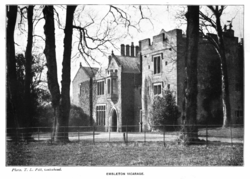
The Church of the Holy Trinity is located in Embleton, Northumberland, England. The church, dedicated to the Holy Trinity, is west of the village. Built in the form of a cross, it consists of a two aisle nave, a clerestory, a chancel, a porch, and a chantry chapel. It has a tower with a small vestry, and a gallery. The vicarage house and garden are on a gradual slope on the south side of the churchyard. Traces of stonework show evidence of an earlier church from the 12th century. It is a Grade I listed building.
Location Image
1.8 km

Embleton Tower

Embleton Tower is a peel tower and Grade I listed building in the village of Embleton in Northumberland, England. Tradition states that in 1395, the tower was built to protect the minister and parishioners of Embleton's Church of the Holy Trinity after the village suffered from a raid by the Scots. The first vicarage was provided for the vicar of Embleton by Merton College, Oxford, who held the patronage of the parish, in 1332. According to Montagu Francis Finch Osborn (1843–1910), vicar of Embleton in 1884, vicarages were erected at three different periods; by 1416, the Vicar's Turris de Emyldon was known to exist. The present building includes a house built in about 1828 as a vicarage adjoining the tower.
Location Image
1.8 km

Dunstanburgh Castle

Dunstanburgh Castle is a 14th-century fortification on the coast of Northumberland in northern England, between the villages of Craster and Embleton. The castle was built by Thomas, 2nd Earl of Lancaster between 1313 and 1322, taking advantage of the site's natural defences and the existing earthworks of an Iron Age fort. Thomas was a leader of a baronial faction opposed to King Edward II, and probably intended Dunstanburgh to act as a secure refuge, should the political situation in southern England deteriorate. The castle also served as a statement of the Earl's wealth and influence and would have invited comparisons with the neighbouring royal castle of Bamburgh. Thomas probably only visited his new castle once, before being captured at the Battle of Boroughbridge in 1322 as he attempted to flee royal forces for the safety of Dunstanburgh. Thomas was executed, and the castle became the property of the Crown before passing into the Duchy of Lancaster. Dunstanburgh's defences were expanded in the 1380s by John of Gaunt, 1st Duke of Lancaster, in the light of the threat from Scotland and the peasant uprisings of 1381. The castle was maintained in the 15th century by the Crown, and formed a strategic northern stronghold in the region during the Wars of the Roses, changing hands between the rival Lancastrian and Yorkist factions several times. The fortress never recovered from the sieges of these campaigns, and by the 16th century the Warden of the Scottish Marches described it as having fallen into "wonderfull great decaye". As the Scottish border became more stable, the military utility of the castle steadily diminished, and King James I finally sold the property off into private ownership in 1604. The Grey family owned it for several centuries; increasingly ruinous, it became a popular subject for artists, including Thomas Girtin and J. M. W. Turner, and formed the basis for a poem by Matthew Lewis in 1808. The castle's ownership changed during the 19th and 20th centuries; by the 1920s its owner Sir Arthur Sutherland could no longer afford to maintain Dunstanburgh, and he placed it under the guardianship of the state in 1930. When the Second World War broke out in 1939, measures were taken to defend the Northumberland coastline from a potential German invasion. The castle was used as an observation post and the site was refortified with trenches, barbed wire, pill boxes and a minefield. In the 21st century, the castle is owned by the National Trust and run by English Heritage. The ruins are protected under UK law as a Grade I listed building and are part of a Site of Special Scientific Interest, forming an important natural environment for birds and amphibians. Dunstanburgh Castle was built in the centre of a designed medieval landscape, surrounded by three artificial lakes called meres covering a total of 4.25 hectares (10.5 acres). The curtain walls enclose 9.96 acres (4.03 ha), making it the largest castle in Northumberland. The most prominent part of the castle is the Great Gatehouse, a massive three-storey fortification, considered by historians Alastair Oswald and Jeremy Ashbee to be "one of the most imposing structures in any English castle". Rectangular towers protect the walls, including the Lilburn Tower, which looks out towards Bamburgh Castle, and the Egyncleugh Tower, positioned above Queen Margaret's Cove. Three internal complexes of buildings, now ruined, supported the earl's household, the castle constable's household, and the running of the surrounding estates. A harbour was built to the southeast of the castle, of which only a stone quay survives.