
 English
 Français
Doddington (Cheshire)
Doddington est un village et une paroisse civile du Cheshire, en Angleterre. Elle se trouve au nord-est d'Audlem et au sud de Crewe. Administrativement, il relève de l'autorité unitaire de Cheshire East. Les villages voisins sont Blakenhall, Bridgemere, Checkley cum Wrinehill, Hatherton, Walgherton et Wybunbury. La A51 traverse la paroisse civile du nord au sud. Doddington comptait un peu moins de 50 habitants en 2001.
Lieux à Proximité Voir Menu
0 m
Doddington, Cheshire
Doddington is a former civil parish, now in the parish of Doddington and District, in the unitary authority area of Cheshire East and the ceremonial county of Cheshire, England, which lies to the north east of Audlem and to the south of Crewe. Nearby villages include Blakenhall, Bridgemere, Checkley, Hatherton, Walgherton and Wybunbury. The A51 runs north–south through the parish.
In 2001, the civil parish had a population of 44. At the 2011 census the population remained less than 100. Details are included in the civil parish of Plumley.

827 m
Delves Hall
Delves Hall, also known as Doddington Castle, is a fortified structure in Doddington Park to the north of Doddington Hall in the civil parish of Doddington, Cheshire, England. It is designated by Historic England as a Grade I listed building.

1.2 km
Lea, Cheshire
Lea is a former civil parish, now in the parish of Doddington and District, in the unitary authority area of Cheshire East and the ceremonial county of Cheshire, England, which lies to the north east of Audlem and to the south of Crewe. The parish was predominantly rural, but it includes the hamlet of Lea Forge (at SJ707486). Nearby villages include Betley, Blakenhall, Hough, Walgherton and Wybunbury.
According to the 2001 census, it had a population of 25. At the time of the 2011 Census the population remained less than 100. Details are included in the civil parish of Blakenhall, Cheshire.
1.4 km
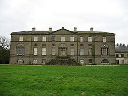
Doddington Hall, Cheshire
Doddington Hall is a country house in Doddington Park in the civil parish of Doddington, Cheshire, England. It is recorded in the National Heritage List for England as a designated Grade I listed building. The house was built for Rev Sir Thomas Broughton between 1777 and 1798 to a design by Samuel Wyatt. It was built to replace an older house, of which Delves Hall was a part, a short distance to the north. The house is constructed of Keuper sandstone ashlar with a slate roof and lead flashings in three storeys. It is in neoclassical style with an entrance front of nine bays.
It is the seat of the Broughton baronets.

1.4 km
Blakenhall, Cheshire
Blakenhall is a small village and former civil parish, now in the parish of Doddington and District, in the unitary authority area of Cheshire East and the ceremonial county of Cheshire, England, about 7 miles (11 km) south-east of Nantwich. It lies on the county boundary with Staffordshire. The parish has an area of 654 hectares (1,620 acres) and also includes the small settlements of The Den and Gonsley Green, with a total population of 125 in 2001. Nearby villages include Wybunbury in Cheshire and Betley and Wrinehill in Staffordshire. Blakenhall was first recorded in the Domesday survey as Blachenhale, and the parish had one of Cheshire's early ironworks in the 17th and 18th centuries. The area is rural and predominantly agricultural, with small areas of ancient woodland and the nature reserve of Blakenhall Moss, a rejuvenating lowland raised bog. The Crewe-to-Stafford railway line runs through the parish and it is on the proposed route of HS2.