
 English
 Français

Bootle Oriel Road railway station
Bootle Oriel Road railway station is a railway station in Bootle, Merseyside, England. It is situated near the town's Victorian civic centre, opposite Bootle Town Hall, although the surrounding area is now largely residential. It is located on the Northern Line of the Merseyrail network.
Nearby Places View Menu

155 m
Bootle Town Hall
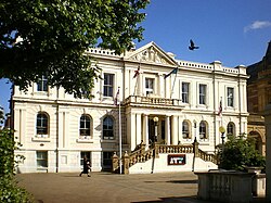
Bootle Town Hall is a municipal building in Oriel Road in Bootle, Merseyside, England. The building, which is the headquarters of Sefton Council, is a Grade II listed building.
179 m
Bootle Village railway station
Bootle Village railway station was a station in Bootle, Lancashire, England, which opened in 1850 and closed in 1876.
The station opened as Merton Road on 1 October 1850 when the Liverpool, Crosby and Southport Railway (LC&SR) extended its line from Waterloo south into Liverpool. It was renamed within the first few months to try and prevent passengers getting confused and using the East Lancashire Railway's Bootle Lane station, which might have cost the LC&SR revenue.
The station was situated on the southern side of Merton Road where it crossed the railway on a bridge, there were two platforms, one each side of the double-track with a station building located on the east side.
The station closed on 1 May 1876 when it, and Miller's Bridge station, were replaced by Bootle Oriel Road which was built between them.

230 m
Bootle Balliol Road railway station
Balliol Road railway station was on the Alexandra Dock Branch, Bootle, Merseyside, England, it opened on 5 September 1881 and closed to passengers on 31 May 1948. Goods trains to and from Seaforth Dock still pass through the station site.
252 m
Metropolitan Borough of Sefton
The Metropolitan Borough of Sefton is a metropolitan borough of Merseyside, England. It was formed on 1 April 1974, by the amalgamation of the county boroughs of Bootle and Southport, the municipal borough of Crosby, the urban districts of Formby and Litherland, and part of West Lancashire Rural District. It consists of a coastal strip of land on the Irish Sea which extends from Southport in the north to Bootle in the south, and an inland part to Maghull in the south-east, bounded by the city of Liverpool to the south, the Metropolitan Borough of Knowsley to the south-east, and West Lancashire to the east.
It is named after Sefton, near Maghull. When the borough was created, a name was sought that would not unduly identify the borough with any of its constituent parts, particularly the former county boroughs of Bootle and Southport. The area had strong links with both the Earl of Sefton and the Earl of Derby, resident of Knowsley Hall, and the adjacent borough was subsequently named Knowsley. A Sefton Rural District covering some of the villages in the district existed from 1894 to 1932.