
 English
 Français

Whaley Bridge
Whaley Bridge est une petite ville et paroisse civile située dans le district de High Peak dans le Derbyshire (Angleterre). La ville est située sur la rivière Goyt à 26 km (16 miles) au sud-est de Manchester, à 11 km (7 miles) au nord de Buxton, à 14 km (9 miles) à l'est de Macclesfield et à 45 km (28 miles) à l'ouest de Sheffield. La ville compte 6 455 habitants (recensement de 2011) en ce compris les habitants de Furness Vale, Hornwich End, Bridgement, Fernilee, Stoneheads et Taxal.
Nearby Places View Menu
0 m
Whaley Bridge
Whaley Bridge () is a town and civil parish in the High Peak district of Derbyshire, England. It is situated on the River Goyt, 16 miles (26 km) south-east of Manchester, 7 miles (11 km) north of Buxton, 9 miles (14 km) north-east of Macclesfield and 28 miles (45 km) west of Sheffield. The parish includes Furness Vale, Horwich End, Bridgemont, Fernilee, Stoneheads and Taxal; the parish had a population of 6,311 at the 2021 census. Whaley Bridge historically straddled Derbyshire and Cheshire until boundary changes in 1936 placed it entirely in Derbyshire.

91 m
Whaley Bridge railway station
Whaley Bridge railway station serves the Peak District town of Whaley Bridge, in Derbyshire, England. It is a stop on the Buxton Line, 16+1⁄4 miles (26.2 km) south-east of Manchester Piccadilly.

343 m
Buxton Road Bridge
Buxton Road Bridge is a railway bridge over the A5004 road in Whaley Bridge, in the High Peak district, in the county of Derbyshire, England. It carries the Buxton line.
512 m
Todd Brook
Todd Brook is a small river running through the English counties of Cheshire and Derbyshire.
The Brook rises beneath Shining Tor on the border between the two counties and flows northwards through east Cheshire, passing by Jenkin Chapel, Windgather Rocks and Kettleshulme before turning east, forming the border between Cheshire and Derbyshire for a short distance before filling Toddbrook Reservoir in Derbyshire.
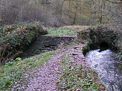
The brook flows into the River Goyt at Whaley Bridge.
The brook's Environment Agency pollution classification changed from good to moderate in 2014.
886 m
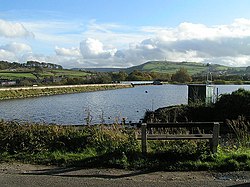
Toddbrook Reservoir
Toddbrook Reservoir, a feeder for the Peak Forest Canal, opened in 1838. It is above the town of Whaley Bridge in the High Peak area of Derbyshire, England. The reservoir is a Site of Special Scientific Interest (SSSI) providing habitats for herons, ducks and other animals and fish, while rare mosses and liverworts grow on its shores, particularly short-lived species that grow on seasonally exposed mud. The reservoir is used for sailing and angling. The Peak District Boundary Walk runs around the eastern end of the reservoir. The reservoir is owned by the Canal & River Trust and, like the nearby Combs Reservoir, is a feeder reservoir for the Peak Forest Canal. The feeder runs through Whaley Bridge, and with the Combs feed enters the canal system in a pool close to the transhipment shed at the Whaley Bridge canal basin.
The reservoir is fed from the Todd Brook, a stream which has a catchment area of around 1,700 hectares (4,200 acres) including the moorland on Shining Tor and farmland around Kettleshulme village. Water enters the reservoir on its north bank via a small waterfall. The first several inches of water do not flow into the reservoir but flow down the reservoir's run-off into the River Goyt. The reservoir often receives little or no inflow during periods when rainfall does not allow the level to exceed the barrier, and this often affects the reservoir's water level, particularly in the summer months.
The reservoir's dam is built from earth with a puddle clay core. The embankment is straight in plan and approximately 310 m (1,020 ft) long. The average crest level is 187.3 metres (615 ft) AOD. In August 2019, concrete panels on its spillway were dislodged after heavy rain, triggering the evacuation of parts of Whaley Bridge and the surrounding area due to the possibility of the dam collapsing.