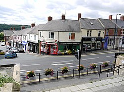
Chapel House is a suburban housing estate in the outer west of Newcastle upon Tyne, England, that was designed by John. T. Bell and built from 1964 until the early 1970s. Made up of private properties, it is approximately 5 miles (8 km) directly from the city centre. It is bordered by Chapel Park, Westerhope, West Denton and Blucher. Before 2005, Chapel House estate had a middle school, Chapel House Middle School, which catered for about 500 children in the area and beyond. However, this closed in 2005 when the outer west of Newcastle switched to two-tier education. Similarly, Knoplaw Primary School and Milecastle Primary School (also within Chapel House) used to be first schools. Chapel House Middle School's land has been built on and now houses Knoplaw Primary School. A groundbreaking event was held on 7 July 2009. Thomas Bewick School and Walbottle Campus Lower School are no longer situated there. A campaign by local residents in 2011 led to the protection of Chadderton Field from planned development. It thus became only the second village green to be registered in the city, under the Commons Act, 2006. Chapel House has a range of buses, (Service Number 40, 11, 72 and 38A) which enable people to get to Newcastle City Centre within 35 minutes. There are five bus stops in the area as well as three bus routes, all going to the city centre (and then beyond to places such as Wallsend, North Kenton and High Heaton) All services are provided by Stagecoach in Newcastle. There are local shops, two churches, two GP surgeries and a dentist.

Nearby Places View Menu
Location Image
594 m

Walbottle

Walbottle is a village in the Newcastle upon Tyne district, in the county of Tyne and Wear, England. It is west of Newcastle upon Tyne.
Location Image
796 m

Milecastle 9

Milecastle 9 (Chapel House) was a milecastle of the Roman Hadrian's Wall. Its remains exist partially as a low platform, and are located in West Denton (to the west of Newcastle upon Tyne), 300 yards (270 m) from Chapel House Farm. However, the northern part of the remains are now mostly covered by the modern roads (A69/B6528). The milecastle marks a watershed between those with relatively well-defined positions (to the west) and those whose position are less certain (to the east). Milecastle 9 (Chapel House) was a milecastle of the Roman Hadrian’s Wall. Constructed during the early 2nd century AD under Emperor Hadrian, it formed part of the defensive network that marked the northern frontier of Roman Britain. Its remains, though mostly buried beneath modern roads, provide evidence of Roman military architecture and the organization of frontier defenses in the region.
Location Image
796 m

Newburn Town Hall

Newburn Town Hall is a former municipal building in Newburn Road, Newburn, a district of Newcastle upon Tyne, in Tyne and Wear, England. The building, which is currently in mixed commercial and residential use, is a Grade II listed building.
Location Image
875 m

Newburn

Newburn, also known as Newburn-upon-Tyne is a village and district of Newcastle upon Tyne, in Tyne and Wear, England. Situated on the North bank of the River Tyne, it is built rising up the valley from the river. It is situated approximately 5 miles (8 km) from the city centre, 14 miles (23 km) east of Hexham and 13 miles (21 km) south south west of Morpeth. In the 2001 census, the population was given as 9,301, increasing to 9,536 at the 2011 Census. Newburn is in the Newcastle upon Tyne district of Tyne and Wear and is part of the parliamentary constituency of Newcastle upon Tyne North. Historically, the area was larger than Newcastle upon Tyne as it was the most eastern fordable point of the River Tyne. The area has Roman remains, and a Norman church dating from 1070 AD. In 1640, the Battle of Newburn took place. The area grew with the Industrial Revolution with the discovery of coal, and in 1822 Spencer's Steelworks was opened. The village's steelworks fell into decline after the First World War, and the area is now home to a country park and various leisure facilities.