
 English
 Français
Gaddum's Wood is a woodland in Cheshire, England, near Wilmslow. It covers a total area of 0.52 hectares (1.28 acres). It is owned and managed by the Woodland Trust.
Nearby Places View Menu
1.1 km
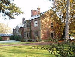
Newton Hall, Mobberley
Newton Hall is a country house east of the village of Mobberley, Cheshire, England. It was built between 1634 and 1676 for Francis Newton. Additions were made to the house in the 19th and 20th centuries. It is constructed in brick that has been rendered and whitewashed, and has stone dressings and slated roofs. The house has three storeys, and along the entrance front are three gables with bargeboards dating from the 19th century. In the ground floor are five windows, all in 20th-century metal frames. In the upper floors are 19th-century two-light casement windows. To the left of the house is a large 20th-century extension, and behind it is a wing dating from the 17th century. The house is recorded in the National Heritage List for England as a designated Grade II listed building. The gate piers, dating from the 18th century, are also listed at Grade II.

1.3 km
St Wilfrid's Church, Mobberley
St Wilfrid's Church stands to the north of the village of Mobberley, Cheshire, England. The church is recorded in the National Heritage List for England as a designated Grade I listed building. It is an active Anglican parish church in the diocese of Chester, the archdeaconry of Macclesfield and the deanery of Knutsford. Alec Clifton-Taylor includes it in his list of 'best' English parish churches.
1.5 km
Mobberley Old Hall
The Old Hall is a country house in the village of Mobberley, Cheshire, England. It was built in 1612 and extended later in the 17th century. The house stands in gardens which retain part of the moat and ancient yew trees. The house is recorded in the National Heritage List for England as a designated Grade II* listed building, and the grounds contain two Grade II listed buildings.
1.6 km
Bucklow Rural District
Bucklow Rural District was, from 1894 to 1974, a local government district in the north of the administrative county of Cheshire, England. Following the Local Government Act 1972, this rural district was split between the new Greater Manchester boroughs of Trafford and Manchester, and Macclesfield, which was retained in Cheshire.
Knutsford was an enclave and independent urban district surrounded by Bucklow RD, as was Altrincham until it expanded enough to link up with other districts in the north.
The district was formed in 1894 based on Altrincham rural sanitary district by the Local Government Act 1894. It was known as the Altrincham Rural District until 1895. The three civil parishes of Northenden, Northen Etchells and Baguley were also part of the Bucklow Rural District until 1931, when Manchester Corporation, which had been given the Wythenshawe estate for municipal housing development, successfully petitioned Parliament to enable their transfer into Manchester.
It was abolished and split up under the Local Government Act 1972 in 1974. The parish of Ringway (including Manchester Airport) went to Manchester, and the parishes of Carrington, Dunham Massey, Partington and Warburton went to Trafford. The remainder remained in Cheshire and became part of the new Macclesfield district.