Luingne ( LWEEN; French pronunciation: [lwin] or [lɥiɲ]; Dutch: Lowingen; Picard: Loinne) is a village of Wallonia and a district of the municipality of Mouscron, located in the province of Hainaut, Belgium. It was a municipality in its own right before the 1977 fusion of municipalities. The inhabitants are called "Cleugnottes". The district is 554-acre large.

1. Dioceses

In 1117, a charter was signed by Ernulfus de Luina. Pope Pascal II (1090-1118) mentions Luingne's altar in a papal bull. A bull of Clement III (1187-1191) confirmed that the chapel and its grounds had been given to the chapter of Tournai. In 1146 the diocese of Tournai was separated from the diocese of Noyon and the presbytery of Luingne became part of the deanery of Helchin. In 1569 the bishop divided this deanery into Helchin-Flamand and Helchin-Wallon, of which Luingne is a part. In 1801, Napoleon created the diocese of Ghent and Luingne (like Mouscron and Herseaux) became part of the deanery of Menin. In 1932, Monsignor Lamiroy, bishop of Bruges, created a French-speaking deanery within his Flemish diocese, grouping together Mouscron-Comines and the surroundings. In 1967, this deanery was attached to the diocese of Tournai under Monsignor Himmer.

1. Religious monuments

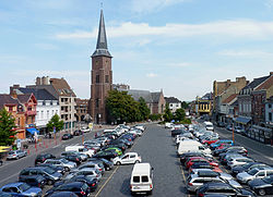
The church has always been in the same place throughout the years. It is even possible that a romanesque building was there before; a drawing from 1813 by Séraphin Vermote represents it. A condemnation for iconoclast destructions committed in the church of Luingne on 24 August 1566 is known thanks to a judgement in Courtrai. The wars of Louis XIV would not spare it either and in 1676 a request was presented in order to repair it. During the French Revolution in 1794, a budget was drawn up to replace the goods that had been pillaged by the sans-culottes. The decision to demolish the old church was made between 1848 and 1850 due to its instability and its small size. A new church, in a neo-Gothic style, named Saint-Amand replaced it at a cost of 40,129 Belgian francs. The building is 20 metres long, 18 metres wide and 15 metres tall. The clock-tower is 42.80 metres high.

1. Sources

"Le cleugnottte", a periodic bulletin of the village of Luingne

1. References


1. External links

Histoire de Luingne www.villagedeluingne.be

Nearby Places View Menu
Location Image
1.2 km

Mouscron

Mouscron (French pronunciation: [mukʁɔ̃] ; Dutch and West Flemish: Moeskroen, Dutch pronunciation: [muˈskrun] ; Picard and Walloon: Moucron) is a municipality and city of Wallonia located in the Belgian province of Hainaut, along the border with the French city of Tourcoing, which is part of the Lille metropolitan area. The municipality consists of the following districts: Dottignies, Herseaux, Luingne, and Mouscron. In accordance with the national law, the municipality offers facilities for the Dutch speaking minority. Kortrijk, in Flanders, is located just to the north of Mouscron. The city substantially grew during the 19th and early 20th century with the development of the textile industry in the north of France. The symbol of the city is the Hurlu: a character representing Protestant activists, who plundered the countryside during the Wars of Religion (16th century).
Location Image
1.2 km

Battle of Mouscron

The Battle of Mouscron (28–29 April 1794) was a series of clashes that occurred when the Republican French Army of the North under Jean-Charles Pichegru moved northeast to attack Menin (now Menen) and was opposed by Coalition forces under the overall leadership of François Sébastien Charles Joseph de Croix, Count of Clerfayt. In their initial advance, the French began the siege of Menin and captured Courtrai (now Kortrijk). With Habsburg Austrian reinforcements, Clerfayt counterattacked on the 28th but Joseph Souham soon massed superior French forces and drove the Coalition troops out of the area. This Flanders Campaign action happened during the War of the First Coalition, part of the French Revolutionary Wars. The battle occurred near Mouscron, Belgium, located at the French border 9 kilometres (6 mi) south of Kortrijk and at Menen, located 11 kilometres (7 mi) west of Kortrijk. Because most of the Coalition army was covering the Siege of Landrecies, the early French advance was largely successful in driving back a weak screen of Hanoverian troops. On the north bank of the Lys River, a division under Jean Victor Marie Moreau besieged Menen, while Souham's division operated on the south bank. Clerfayt's foray enjoyed initial success at Mouscron, but Souham on his own initiative concentrated superior forces against the Coalition. Completely isolated by Clerfayt's defeat, the largely Hanoverian garrison of Menin under Rudolf von Hammerstein broke out of the fortress and escaped on the 30th. The next action occurred at the Battle of Courtrai on 10 May.
Location Image
1.6 km

Stade Le Canonnier

Le Canonnier is a multi-use stadium in Mouscron, Belgium. It is currently used mostly for football matches and was the home ground of Royal Excel Mouscron until the club was folded in 2022. The stadium holds 10,800 people.
Location Image
3.7 km

Hôtel de Ville, Wattrelos

The Hôtel de Ville (French pronunciation: [otɛl də vil], City Hall) is a municipal building in Wattrelos, Nord, in northern France, standing on Place Jean-Delvainquière.