
 English
 Français

Barmby Moor
Barmby Moor est une paroisse civile et un village du Yorkshire de l'Est, en Angleterre.
1. Notes et références
(en) Cet article est partiellement ou en totalité issu de l’article de Wikipédia en anglais intitulé « Barmby Moor » (voir la liste des auteurs).
1. Liens externes
Ressource relative à la géographie : Open Domesday
Portail du Yorkshire
Nearby Places View Menu

0 m
Barmby Moor
Barmby Moor is a village and civil parish in the East Riding of Yorkshire, England. It is situated approximately 1.5 miles (2.4 km) west of the market town of Pocklington and 12.5 miles (20 km) east-southeast of the city of York. It lies north of the A1079 road where it is met by the B1246 road that passes through the village.
According to the 2011 UK census, Barmby Moor parish had a population of 1,114, an increase on the 2001 UK census figure of 1,065.
The name Barmby derives from the Old Norse bjarnibȳ or barnebȳ meaning 'Bjarni's' or 'Barne's village'. Perhaps, it could also derive from barnbȳ meaning 'child's village'.
The village was originally a market town with a coaching inn. It has a church, dedicated to St Catherine, chapel, village hall and a primary school. There is also a post office and a pub, The Boot & Slipper. The church and the Manor House were designated as Grade II* listed buildings in 1967 and are now recorded in the National Heritage List for England, maintained by Historic England.
Each July a traditional fete – the Barmby Feast – is held in the village.
1.3 km
RAF Pocklington
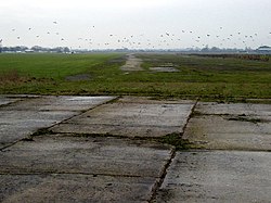
Royal Air Force Pocklington or more simply RAF Pocklington was an operational flying station of the Royal Air Force during the Second World War, forming part of RAF Bomber Command, and operating primarily Vickers Wellington and Handley Page Halifax bombers. The station, adjacent to the town of Pocklington at grid reference SE790485, opened in 1941, and was closed in 1946. After a return to agricultural use, the station now forms an industrial estate and a restricted use airfield for a gliding club.

1.7 km
Allerthorpe
Allerthorpe is a village and civil parish in the East Riding of Yorkshire, England. It is situated approximately 1.5 miles (2.4 km) south-west from the town of Pocklington.
The civil parish is formed by the village of Allerthorpe and the hamlet of Waplington.
According to the 2011 UK census, Allerthorpe parish had a population of 220, a slight reduction from the 2001 UK census figure of 223. The parish covers an area of 969.217 hectares (2,394.99 acres).
The name Allerthorpe derives from either an Old English or Old Norse personal name, perhaps Aelfweard or Alfvarthr, and the Old Norse þorp meaning 'secondary settlement'.
Allerthorpe has a public house, The Plough Inn, an 18-hole golf course and a lake used for water sports and fishing. Allerthorpe Common, to the west of the village, has a nature reserve.
Allerthorpe's Victorian Grade II listed Anglican parish church is dedicated to St Botolph.
From the mediaeval era until the 19th century Allerthorpe was part of Harthill Wapentake.
Between 1894 and 1974 it was a part of the Pocklington Rural District, in the East Riding of Yorkshire. Between 1974 and 1996 it was part of the Borough of North Wolds (later Borough of East Yorkshire), in the county of Humberside.
The K6 telephone box on Main Street is Grade II listed.
Thomas Cooke, the machinist and optical instrument maker, was born here. There is a memorial stone to him near the church gate and a blue plaque was unveiled in the village hall in 2009.
William Dewsbury the Quaker minister was born in the village.
2.0 km
Yapham Gate railway station
Yapham Gate railway station was a station on the York to Beverley Line in the East Riding of Yorkshire, England. It opened on 4 October 1847 and served the village of Yapham. It was short lived and closed in April 1865.

2.3 km
Pocklington School
Pocklington School is a private day and boarding school in Pocklington, East Riding of Yorkshire, England. It was founded in 1514 by John Dolman. The school is situated in 50 acres (20 ha) of land, on the outskirts of the small market town, 12 miles (19 km) from York and 26 miles (42 km) from Hull. It is the 67th oldest school in the United Kingdom and celebrated its 500th anniversary in 2014.