
 English
 Français
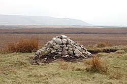
Anglezarke
Anglezarke is a sparsely populated civil parish in the Borough of Chorley in Lancashire, England. It is an agricultural area used for sheep farming and is also the site of reservoirs that were built to supply water to Liverpool. The area has a large expanse of moorland with many public footpaths and bridleways. The area is popular with walkers and tourists; it lies in the West Pennine Moors in Lancashire, sandwiched between the moors of Withnell and Rivington, and is close to the towns of Chorley, Horwich and Darwen. At the 2001 census it had a population of 23, but at the 2011 census the population was included within Heapey civil parish. The area was subjected to depopulation after the reservoirs were built.

Manvers
Manvers is a suburb of Wath upon Dearne in the Metropolitan Borough of Rotherham in South Yorkshire, England. It lies across the border with the Metropolitan Borough of Doncaster, whilst Mexborough is part of Doncaster. It is situated between Mexborough and Wath upon Dearne, not far from Swinton.
It is served by Stagecoach Yorkshire, the main route being 220 (Cortonwood/Doncaster Frenchgate), as well as First South Yorkshire and Yorkshire Tiger.

Hendon Beach Lifeboat Station
Sunderland (Hendon Beach) Lifeboat Station was located on the coast between the Wearside and Grangetown areas of Sunderland, in the county of Tyne and Wear.
A lifeboat was first stationed at Hendon Beach in 1902, by the Royal National Lifeboat Institution (RNLI).
After just 10 years in operation, Hendon Beach Lifeboat Station was closed on 11 July 1912.
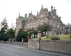
Forfar Sheriff Court
Forfar Sheriff Court is a judicial building in Market Street, Forfar, Angus, Scotland. The building, which remains in use as a courthouse, is a Category B listed building.

Carville railway station
Carville was a railway station on the Riverside Branch, which ran between Byker and Willington Quay. The station served Wallsend in North Tyneside.
The station was opened to passengers on 1 August 1891 by the North Eastern Railway. It was situated near to the junction of Hadrian Road and Park Road.
Despite the station's close proximity to nearby Wallsend, Carville was the busiest station on the Riverside Branch prior to the line's closure.

Newton upon Derwent
Newton upon Derwent or Newton on Derwent is a village and civil parish in the East Riding of Yorkshire, England. It is situated approximately 5 miles (8 km) west of Pocklington and 1 mile (1.6 km) south of the A1079 at Wilberfoss. It lies 1 mile east of the River Derwent after which the village takes its name. According to the 2011 UK census, Newton on Derwent parish had a population of 315, an increase on the 2001 UK census figure of 282.

Greno Woods
Greno Woods is a 178 hectares (440 acres) area of ancient woodland and nature reserve located north of Grenoside village, a suburb of Sheffield, South Yorkshire, England. Previously used as a quarry, hunting ground, and for commercial forestry; it is now used for recreational walking, jogging and mountain biking.

Bellingham Town Hall
Bellingham Town Hall is a municipal building in Front Street in Bellingham, Northumberland, England. The building, which is the meeting place of Bellingham Parish Council, is a Grade II listed building.

Beinn Bhreac (Arrochar)
Beinn Bhreac (681 m) is a mountain in Argyll and Bute, Scotland. It is part of the Luss Hills, a southern subrange of the Grampian Mountains.
Rising from the western shore of Loch Lomond near the village of Tarbet, it takes the form of a rough ridge.

Peasholm railway station
Peasholm railway station is the southern terminus station of the North Bay Railway in Scarborough, North Yorkshire, England. It opened to the public in 1931.
Although named after Peasholm Park, the station is not located in Peasholm Park, but is actually situated across Burniston Road, adjacent to the Open Air Theatre in Northstead Manor Gardens - part of the historic Manor of Northstead.
The station features a single platform with a parallel carriage siding. There is also a balloon loop, to reverse and turn engines, and an engine shed, built in 1931, and enlarged in 2007.
In 2007 the operating company announced plans to rebuild the station during the winter of 2007/2008, providing enhanced passenger and staff facilities, including an enlarged booking office and a new cafeteria. The new booking office is also a souvenir shop and sells light refreshments, which may be consumed in a covered seating area between the shop and the platform. A restaurant, operated by the railway company, is situated adjacent to the station.

Blackburne House
Blackburne House is an 18th-century Grade II listed building located on the east side of Hope Street, Liverpool, Merseyside, England. It was built in 1788 and remodelled in from 1874 to 1876. Originally a private house, it became a girls' school and, after a period of dereliction, it is used as a training and resource centre for women.

St Thomas' Church, Crosscrake
St Thomas' Church is in the village of Crosscrake, Cumbria, England. It is an active Anglican parish church in the Deanery of Kendal, the Archdeaconry of Westmorland and Furness, and the Diocese of Carlisle.
The church was built in 1874–75, and was designed by the Lancaster architects Paley and Austin. It has since been modified but retains its Gothic Revival style.

Mount Pleasant (cricket ground)
Mount Pleasant is a cricket ground in Batley, West Yorkshire. The first recorded match on the ground was in 1869, when Batley played Burnley. The ground hosted a single first-class match in 1883 when the T. Emmett's XI played R. G. Barlow's XI.
The ground, adjacent to the stadium of Batley RLFC, is the home of Batley Cricket Club. They are members of the Central Yorkshire Cricket League.
Rusacks Hotel
Rusacks Hotel, previously known as Macdonald Rusacks Hotel between 2001 and 2019, is a 5-star hotel in St Andrews, Fife, Scotland, overlooking the 1st and 18th greens on the Old Course, St Andrews Links. When it first opened in 1887 it was known as the Marine Hotel, and shortly afterwards, it became Rusack's Marine Hotel. The hotel faces both Pilmour Links and The Links thoroughfare, and overlooks the 1st and 18th greens on the Old Course. In 2021 the hotel was renovated and extended over the old car park, to increase the number of bedrooms to 120.

River Ellen
The Ellen is a river in the English county of Cumbria, flowing from Skiddaw in the Northern Fells to the Solway Firth at Maryport. It was historically in the county of Cumberland. It is approximately 25 miles (40.2 km) in length.

Holderness (borough)
Holderness was a local government district and borough in northern England, named after the Holderness peninsula.
It was formed on 1 April 1974 along with the non-metropolitan county of Humberside in which it was situated. It was formed from part of the administrative county of Yorkshire, East Riding, namely:
The municipal borough of Hedon,
The urban districts of Hornsea and Withernsea,
The Holderness Rural District.
The council's headquarters were at Skirlaugh, in the converted workhouse that had been built in 1838.
On 1 April 1996, Humberside and the borough were abolished, and it became part of the new unitary East Riding of Yorkshire.

Nunthorpe
Nunthorpe is a village and civil parish in the Borough of Middlesbrough in North Yorkshire, England.
It is part of the historic county of Yorkshire, North Riding. It is near to the village of Great Ayton and formerly part of the Ayton ancient parish until 1866.

Owston's Warehouse
Owston's Warehouse is a historic building in Malton, North Yorkshire, a town in England.
A quay was built on the River Derwent in Malton in 1725, with a stone warehouse on it. In the late 18th century, a new warehouse was built adjoining the existing one. It was probably used to store corn, and may have been built for Mr Owston; he was recorded as the tenant in 1809. His yard extended back to Yorkersgate and included a maltings and other buildings to the rear. In the early 20th century, the ground floor openings were blocked up, and the level of the first floor was lowered by 34 inches (86 cm), while retaining the original timbers.
The warehouse is built of red brick with stone dressings and a hipped pantile roof. It has a rectangular plan, three storeys on the river front, two on the yard front, and seven bays. In the centre of the river front is a wide segmental-arched entrance, and there are windows with segmental arches on the current ground floor and flat arches on the upper floor. The yard front contains irregular openings. It has been grade II listed since 1979.
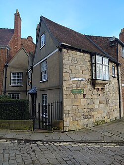
5 Minster Yard
5 Minster Yard is a Grade II* listed building in the city of York, North Yorkshire, England.
The building is wholly timber-framed and is located with its south side facing Minster Yard. It originated as part of a two-storey row of tenements, built about 1300, the row also having included what is now 2 College Street. From this period survive parts of some roof trusses and a rafter. The main range may have been rebuilt in about 1500. In about 1600, a large chimney stack was added, with a new staircase to its north, and a two-storey wing was added on the north side of the building.
The building was heavily altered in 1891, with its south wall rebuilt in stone, including a prominent oriel window. The west gable end was also rebuilt on a new alignment, and a third storey was added to the eastern half of the building. Internally, an entrance hall was created, and a new staircase added, reusing balusters from about 1700. The western first floor room has a fireplace surround and panelling dating from about 1600, and the eastern ground and first floor also have wooden panelling.
The building was listed in 1954, along with its garden railings and gate posts.

Langton, North Yorkshire
Langton is a village and civil parish in North Yorkshire, England. It is situated 3.5 miles (6 km) south from the market town of Malton. The population at the 2011 Census was less than 100. Details are included in the civil parish of Birdsall, North Yorkshire. At the end of the village lies Langton Hall, which offers holiday lettings and is now home to Charles William Langton, a businessman from Leeds, West Yorkshire.
Langton Hall has recently been used for TV filming including Gentleman Jack (Series 2 episode 1) and also featured in Rich House Poor House, (Series 10, episode 2).
Until 1974 the village lay in the historic county boundaries of the East Riding of Yorkshire. Between 1974 and 2023 it was part of the Ryedale district. It is now administered by North Yorkshire Council.
Langton Hall was the home of Woodleigh School, an independent preparatory school founded in 1929 by the educationalist Arthur England, from 1946 until the school's closure in 2012. There is also a small state primary school, Langton Community School with around 80 pupils.
The village was historically the seat of the Norcliffe family. Their former home, Langton Hall, previously owned by their descendants, the Howard-Vyse family, and leased to Woodleigh School until 2012, is a Grade II listed building.
Langton Hall was purchased by William Langton in 2019 (namesake coincidence), who has undertaken a full restoration of the "decaying country pile after falling for its charms".
In 1823 Langton was a civil parish in the East Riding of Yorkshire, and the Wapentake of Buckrose. St Andrew's Church, Langton and the parish living was under the patronage of the King. Population at the time was 280. Occupations included five farmers, two grocers, a tailor & draper, a butcher, a shoemaker, a schoolmaster, a parish constable, and the landlord of Horse Shoes public house who was also a blacksmith. A Major and Mrs Northcliffe were resident at the Hall.