
 English
 Français
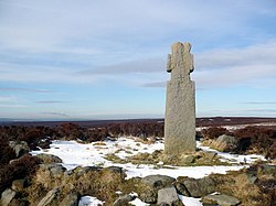
Lilla Cross
Lilla Cross is a marker on Lilla's Howe, Fylingdales Moor, in North Yorkshire, England. A story relates how King Edwin of Northumbria placed the cross there to mark the grave of Lilla, one of his thegns who saved his life during an assassination attempt. Whilst the current cross is believed to date to the 10th century, the original was placed there in 626. Even so, Lilla Cross is known for being the oldest marker of its type on the North York Moors. The ancient cross marks the intersection of pathways across the moor, the edges of four parishes and is also a waymarker on the Lyke Wake Walk.
Nearby Places View Menu

2.9 km
May Moss (bog)
May Moss is a peat bog in the North York Moors National Park, in North Yorkshire, England. The bog is 3.2 kilometres (2 mi) east of the old Saltersgate Inn at a height of 253 metres (830 ft) above sea level, and is the watershed where water feeds Eller Beck to the north, and the River Derwent to the south. The site was a declared an SSSI in June 1983, but was subsumed into the larger North York Moors SSSI in 1998.
3.0 km
Langdale Moor wildfire
The Langdale Moor wildfire started on the evening of 11 August 2025, on Langdale Moor near RAF Fylingdales in North Yorkshire, England. The fire continued to spread over the following days, with resources for fighting the fire pulled in from across the county and with support from neighbouring fire and rescue services. Smoke has been detected up to 130 kilometres (80 mi) from the moors.

3.0 km
RAF Fylingdales
Royal Air Force Fylingdales (RAF Fylingdales) is a Royal Air Force station on Snod Hill in the North York Moors, England. Its motto is Vigilamus ("We are watching"). It is a radar base, former part of the Ballistic Missile Early Warning System (BMEWS), and now part of the Solid State Phased Array Radar System (SSPARS).
As part of intelligence-sharing arrangements between the United States and United Kingdom (see, for example, the UKUSA Agreement), data collected at RAF Fylingdales are shared between the two countries. Its primary purpose is to give the British and US governments warning of an impending ballistic missile attack (part of the so-called four minute warning during the Cold War). A secondary role is the detection and tracking of orbiting objects; Fylingdales is part of the United States Space Surveillance Network.
As well as its early-warning and space-tracking roles, Fylingdales has a third function – the Satellite Warning Service for the UK. It keeps track of spy satellites used by other countries, so that secret activities in the UK can be carried out when they are not overhead. The armed services, defence manufacturers and research organisations, including universities, take advantage of this facility.

3.8 km
Langdale Forest
Langdale Forest is an area of primarily coniferous woodland at the southern end of the North York Moors National Park, in North Yorkshire, England. The forest covers an area of 2,993.8 hectares (7,398 acres) and includes May Moss, a peatland that is recognised by the IUCN. Some areas of coniferous plantations within the forest that have been felled in the 21st century, have been replaced with broad-leaved trees. Alongside neighbouring Dalby Forest, and nearby Cropton Forest, Langdale Forest forms part of the North Riding Forest Park.