
 English
 Français

Mardale Ill Bell is a fell in the English Lake District, rising to the south west of Haweswater Reservoir. It stands on the watershed between Mardale and Kentmere and is the highpoint of the south-eastern ridge of High Street, midway on its course to Harter Fell.
Nearby Places View Menu
531 m
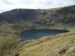
Blea Water
Blea Water is a tarn or corrie lake which occupies a glacially excavated hollow immediately to the east of High Street in the Lake District, England. At just over 200 feet (61 m) deep, it is the deepest tarn in the Lake District.
It is drained by the Mardale Beck, which runs north-east into Haweswater.

1.1 km
High Street (Lake District)
High Street is a fell in the English Lake District. At 828 metres (2,717 ft), its summit is the highest point in the far eastern part of the national park. The fell is named after the Roman road that ran over the summit.

1.5 km
Harter Fell (Mardale)
Harter Fell is a fell in the far eastern part of the English Lake District. The summit at lies the meeting point of three ridges, and Harter Fell forms the head of three valleys: Mardale, Longsleddale and the valley of the River Kent.
1.6 km
Thornthwaite Crag
Thornthwaite Crag is a fell in the English Lake District, standing to the west of Haweswater Reservoir. It is a focal point of the Far Eastern Fells, standing at the head of several valleys.