
 English
 Français

Lamplugh (Cumbria)
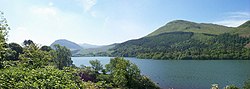
Lamplugh est une paroisse civile et une communauté dispersée de l'ouest de la Cumbria, dans le nord-ouest de l'Angleterre, à la lisière du Lake District anglais, et qui fait historiquement partie du Cumberland. Sa population était de 763 habitants en 2001, et elle est passée à 805 habitants au recensement de 2011. La route principale A5086 reliant Cockermouth à Egremont traverse la paroisse dans le sens nord-sud. Le chemin de fer de Whitehaven, Cleator et Egremont (en), appelé plus tard le LMS, traversait également la paroisse, avec une gare à Wright Green. Au nord de Rowrah, cette ligne a perdu son service de transport de passagers en 1931 et a été fermée à tout trafic en 1954. Fait inhabituel, le village n'a pas de centre évident. L'église St Michael (en) est construite sur le point le plus élevé du village, mais le pub local, le Lamplugh Tip Inn, se trouve à plus d'un kilomètre de là, sur l'A5086. Il a été fermé pendant un certain temps pour rénovation, mais a rouvert ses portes. L'école de Lamplugh (l'école primaire locale) se trouve dans le hameau de Kirkland. La paroisse civile de Lamplugh étant très étendue, elle comprend Kirkland ainsi qu'Eskett et, jusqu'à de récents changements de limites, des parties d'Ennerdale Bridge et de Rowrah. Le village est situé en bordure du parc national du Lake District. Les routes de l'église St Michael en direction de Loweswater et de l'église en direction d'Ennerdale font partie de la limite du parc national, lequel se trouve à l'est de ces routes. Si certaines parties du village se trouvent à l'intérieur du parc national, presque toutes les habitations en sont situées à l'extérieur et sont donc moins chères qu'à Loweswater. Lamplugh est le point de départ d'un certain nombre de randonnées, et se trouve également sur la route cyclable Sea to Sea (en), qui longe les routes formant la limite du parc national décrite ci-dessus. Lamplugh figure sous le nom de « Crossbridge » dans deux romans de Melvyn Bragg : The Hired Man (en) et Without a City Wall. Par ailleurs, le 2 juin 2010, Lamplugh a été le théâtre du premier meurtre de la série d'assassinats connue sous le nom de « Cumbria shootings (en) », lorsque Derrick Bird, de Rowrah, a abattu son frère jumeau, David, qui résidait à Lamplugh.
Nearby Places View Menu

Burnbank Fell

Blake Fell
Loweswater

Cogra Moss
