
 English
 Français
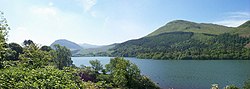
Loweswater is one of the smaller lakes in the English Lake District. The village of Loweswater is situated to the east of the lake.
Nearby Places View Menu

1.5 km
Low Fell (Lake District)
Low Fell is a fell in the English Lake District. It overlooks the lake of Loweswater to the south and to the north is bordered by its neighbour Fellbarrow. It is usually climbed from the villages of Loweswater or Thackthwaite. The fell is largely occupied by grassed enclosures, although there are some rocky outcrops near the top. Low Fell has fairly steep slopes to the south and east.

1.5 km
Burnbank Fell
Burnbank Fell is a small hill in the west of the English Lake District. It is the most westerly of the Loweswater Fells, a group of low grassy hills just south of Loweswater. It is predominantly grassy, with sprawling flanks and a broad ridge connecting it to Blake Fell. It can be climbed from Lamplugh in the west, or from Waterend on the lakeshore.

1.8 km
Loweswater (village)
Loweswater is a village and civil parish in the county of Cumbria, England.

2.5 km
Blake Fell
Blake Fell is a hill in the Western part of the English Lake District. It is the highest point of the Loweswater Fells, an area of low grassy hills with steep sides overlooking the lake of Loweswater. The fell also overlooks the village of Loweswater, from which it can be climbed. An alternative route is from the Cogra Moss reservoir on its western slopes. Because the Loweswater Fells are a separate geographical unit, Blake Fell is a Marilyn. It is located in the Parish of Lamplugh.