
 English
 Français
East Cowick
East Cowick is a village in the East Riding of Yorkshire, England, situated approximately 1.5 miles (2.4 km) east of Snaith. It lies on the A1041 road and just north of the M62 motorway. It was historically part of the West Riding of Yorkshire until 1974. It forms part of the civil parish of Snaith and Cowick.
Nearby Places View Menu
1.3 km
West Cowick
West Cowick is a village located in the civil parish of Snaith and Cowick in the East Riding of Yorkshire, England. It lies in low-lying farmland within the Humberhead Levels.
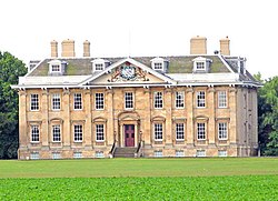
To the east is Cowick Hall, a late seventeenth-century country house listed at Grade I and now the headquarters of Croda International. On 14 June 1323 the Crown issued Exchequer ordinances from Cowick. West Cowick is identified as a production centre for Humber ware pottery, and a 2024 peer-reviewed study analyses the local shift from green to purple glazed wares.

2.1 km
Snaith railway station
Snaith railway station serves the market town of Snaith in the East Riding of Yorkshire, England. It is located 26 miles (42 km) east of Leeds railway station on the Pontefract Line, between Knottingley and Goole.
The station is managed by Northern Trains and is classified by the Department for Transport as category F2.
The former five trains each way per day service of the late 1980s (see British Rail National Passenger Timetables from May 1988–90) was cut in half in 1991 (due to shortage of rolling stock) and again in 2004, leaving only a residual "Parliamentary" minimum timetable in operation east of Knottingley to avoid the need for statutory closure proceedings - a situation that remains unchanged to this day.

2.2 km
Snaith and Cowick
Snaith and Cowick is a civil parish in the East Riding of Yorkshire, England. It is situated approximately 6 miles (9.7 km) west of the town of Goole and covers an area of 2,406.612 hectares (5,946.87 acres).
The civil parish is formed by the town of Snaith and the villages of East Cowick and West Cowick.
According to the 2011 UK census, Snaith and Cowick had a population of 3,579, an increase on the 2001 UK census figure of 3,028.
The parish was part of the Goole Rural District in the West Riding of Yorkshire from 1894 to 1974, then in Boothferry district of Humberside until 1996.

2.2 km
Snaith
Snaith is a market town in the civil parish of Snaith and Cowick in the East Riding of Yorkshire, England.
Snaith is administered by the East Riding of Yorkshire unitary authority and, since the 2024 general election, forms part of the Goole and Pocklington constituency.
It stands close to the River Aire and the M62 and M18 motorways, 7 miles (11 km) west of Goole, 10 miles (16 km) east of Knottingley, 8 miles (13 km) south of Selby, 10 miles (16 km) southwest of Howden and 8 miles (13 km) northwest of Thorne.