
 English
 Français

Hepple
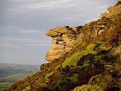
Hepple est une paroisse civile et un village du Northumberland, en Angleterre. La population de la paroisse civile au recensement de 2011 était de 144 habitants.
1. Notes et références
(en) Cet article est partiellement ou en totalité issu de l’article de Wikipédia en anglais intitulé « Hepple » (voir la liste des auteurs).
1. Liens externes
Portail de l’Angleterre
Nearby Places View Menu
1.4 km
Reivers Way
The Reivers Way is a long-distance footpath in Northumberland, passing through the Northumberland National Park and the Cheviot Hills. Totalling 242 kilometres (150 mi) it starts in the Roman township of Corbridge and crosses the Hexhamshire Common before heading up along Hadrians Wall. Via Wark and Rothbury it heads into the Cheviot range via Clennell Street leading up to The Cheviot before dropping down to Wooler. From Wooler the path passes through Belford to the Northumbrian Saxon's capital of Bamburgh, and then follows the Northumberland Coast Path through Seahouses to Alnmouth.
3.0 km
Tosson Hill
Tosson Hill is the highest hill in the Simonside Hills to the south of Rothbury in Northumberland, England. The summit lies about 2 kilometres (1.2 mi) west of Simonside, the best-known summit of the Simonside Hills. It has an elevation of 441.7 m (1,449 ft) and a prominence of 249.1 m (817 ft) and is classed as a Marilyn.
The summit is about 1 kilometre (0.62 mi) west of the edge of the Forestry Commission-owned Simonside Forest, and unlike the rest of the Simonside hills there was no public access to the summit. This has now changed, as the area is 'access land' under the terms of the Countryside and Rights of Way Act 2000.
The sandstone crags at Ravensheugh on the northern side of Tosson Hill offer a variety of short rock climbing routes, and have been described as "A superb crag on top quality sandstone." They are usually less busy than crags within the Simonside Forest.

3.6 km
Holystone, Northumberland
Holystone is a small village and former civil parish, now in the parish of Harbottle, in Northumberland, England.
It lies on the edge of (and just within) the Northumberland National Park on the north bank of the River Coquet. A significant landmark is Holy Well, traditionally the site of early Christian baptisms, and the source of Holystone's water supply. In 1951 the parish had a population of 71.
In the early 12th century Holystone became the home of a priory of Augustinian Canonesses. The priory buildings were demolished during the reformation in 1541.
In 1903, Newcastle upon Tyne-based architect Frank West Rich purchased Dues Hill Grange and 3000 acres of land in Holystone, which he subsequently renovated.

4.3 km
Sharperton
Sharperton is a small settlement and former civil parish, now in the parish of Harbottle, in Northumberland, England. Sharperton is the site of a deserted medieval village, which was documented as having 14 taxpayers in 1296, and described as having two short rows of dwellings in 1632. There was also a bastle (fortified farmhouse) here. In 1951 the parish had a population of 36.
4.4 km
Holystone Burn Woods
Holystone Burn Woods is a Site of Special Scientific Interest (SSSI) within Northumberland National Park in Northumberland, England. It is located near the village of Holystone. The protected area includes part of the valley along which flows the stream called Holystone Burn. Part of the protected area is managed by the Northumberland Wildlife Trust.