
 English
 Français

Cambeck Bridge
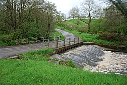
Cambeck Bridge is a hamlet in Cumbria, England. The bridge itself was built in the 19th century and spans the River Irthing. It is a Grade II listed building, listed in 1984.
1. References
Nearby Places View Menu

1.1 km
Milecastle 57
Milecastle 57 (Cambeckhill) was a milecastle on Hadrian's Wall (grid reference NY50816368).

1.1 km
Camboglanna
Camboglanna (with the modern name of Castlesteads) was a Roman fort. It was the twelfth fort on Hadrian's Wall counting from the east, between Banna (Birdoswald) almost 7 miles (11 km) to the east and Uxelodunum (Stanwix), 9 miles to the west. It was on a high bluff commanding the Cambeck Valley. It guarded an important approach to the Wall and also watched the east bank of the Cambeck against raiders from the Bewcastle area. The site was drastically levelled in 1791 when the gardens of Castlesteads House were laid over it. The name "Camboglanna" is believed to mean "Crook Bank", or "Bent Valley" because it overlooks a bend in the river Irthing; the name is Brythonic, made of cambo- "curved, bent, crooked" and glanna "steep bank, stream/river side, valley with a stream".
There was some confusion over the Roman name for the fort. At one time Camboglanna was the accepted name for Birdoswald, but this is now believed to be an error in the Notitia Dignitatum. The Roman name for Birdoswald is now thought to be Banna.

1.1 km
Brampton Old Church
Brampton Old Church stands about 1 mile (2 km) to the west of the town of Brampton, Cumbria, England. It was originally the parish church of Brampton but is now redundant. The church is recorded in the National Heritage List for England as a designated Grade II* listed building.