
 English
 Français

Rolston
Rolston is a hamlet in the East Riding of Yorkshire, England, in an area known as Holderness. It is situated approximately 2 miles (3.2 km) south of Hornsea and lies just west of the B1242 road.
It forms part of the civil parish of Mappleton. The name Rolston derives from the Old Norse personal name Rolf and the Old English tūn meaning 'settlement'.
1. References


1. External links
Rolston in the Domesday Book
Nearby Places View Menu

1.7 km
Mappleton
Mappleton is a village and civil parish in the East Riding of Yorkshire, England. It is situated on the North Sea coastline in an area known as Holderness, lying approximately 3 miles (5 km) south of the seaside resort of Hornsea.
The civil parish is formed by the village of Mappleton and the hamlets of Cowden, Great Cowden and Rolston.
According to the 2011 UK census, Mappleton parish had a population of 342, an increase on the 2001 UK census figure of 249.
The parish church of All Saints is a Grade II* listed building.

2.7 km
Wassand railway station
Wassand railway station was a railway station that served the villages of Wassand and Goxhill in the East Riding of Yorkshire, England. It was on the Hull and Hornsea Railway.
It opened in 1865, and was originally named "Goxhill". It was renamed "Wassand" (to avoid confusion with Goxhill in Lincolnshire) on 1 October 1904, and closed on 21 September 1953.
2.7 km
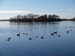
Hornsea Mere
Hornsea Mere is the largest freshwater lake in Yorkshire,
England, and lies to the west of Hornsea in the East Riding of Yorkshire. The mere was used as a base for the Royal Naval Air Service and then latterly, the Royal Air Force during the First World War.

2.9 km
Goxhill, East Riding of Yorkshire
Goxhill is a small hamlet in the civil parish of Hatfield, in the East Riding of Yorkshire, England in an area known as Holderness. It is situated approximately 2 miles (3.2 km) south-west of Hornsea town centre. In 1931 the parish had a population of 70.
On 1 April 1935 the parish was abolished and merged with Great Hatfield and Little Hatfield to form Hatfield.
The name Goxhill could perhaps be derived from the Old Norse geysill meaning 'a gush of water'.
The parish church of St Giles is a Grade II listed building.
In 1823, Goxhill parish was in the Wapentake and Liberty of Holderness. At the time, the parish church was undergoing repairs, begun in 1818. The population was 70, which included five farmers. In 1840 the population was 65, again with five farmers, the parish land of 880 acres (3.6 km2) the property of Rev Charles Constable, who had been patron of the St Giles Church incumbent since 1823.
Goxhill was served from 1865 to 1953 by Wassand railway station on the Hull and Hornsea Railway.