
 English
 Français

High Peak (UK Parliament constituency)
High Peak is a parliamentary constituency represented in the House of Commons of the UK Parliament since 2024 by Jon Pearce of the Labour Party. The constituency is in north west Derbyshire and based in the heart of the Peak District, including the towns of Buxton, Glossop and New Mills. Since the 1966 general election, the seat has been somewhat of a bellwether, with only three exceptions: at the February and October 1974 general elections the seat was won by the Conservative Party when the Labour Party won the most seats nationally, and at the 2017 general election when the seat was won by Labour but the Conservatives won the most seats nationally.
Nearby Places View Menu
0 m
High Peak, Derbyshire
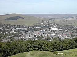
High Peak is a local government district with borough status in Derbyshire, England, covering a high moorland plateau in the Dark Peak area of the Peak District National Park. The district stretches from Holme Moss in the north to Sterndale Moor in the south, and from Hague Bar in the west to Bamford in the east. The population of the borough taken at the 2011 Census was 90,892. The borough is unusual in having two administrative centres for its council, High Peak Borough Council; the offices are in Buxton and Glossop. Other towns include Chapel-en-le-Frith, Hadfield, New Mills and Whaley Bridge.
High Peak was the name of a hundred of the ancient county of Derbyshire covering a larger area than the current district with the hundred including the town of Bakewell and extending just to the west of Matlock. It may have derived its name from the ancient Forest of High Peak, a royal hunting reserve administered by William Peverel, a favourite of William I, who was based at Peak Castle. High Peak contains much of the Peak District National Park. The district contains the highest point in Derbyshire, Kinder Scout, which stands at 636m (2,087 ft) above sea level. Its settlements act as commuter centres for people who work in the surrounding counties and other parts of Derbyshire, owing to its proximity to Cheshire, Greater Manchester, South Yorkshire, Staffordshire and West Yorkshire.

1.1 km
Cowburn Tunnel
The Cowburn Tunnel is a railway tunnel at the western end of the Vale of Edale in the Derbyshire Peak District of England. The tunnel is 3,702 yards (3,385 m) long. It is the deepest railway tunnel in England, at 875 feet (267 m).

1.3 km
Rushop
Rushop or Rushup is a hamlet in Derbyshire, in the parish of Chapel-en-le-Frith. The main cluster of buildings lies on Rushup Lane, which connects the hamlet of Perryfoot to the south and the former A625 road, now unclassified, below Rushup Edge to the north.
There is archaeological and documentary evidence that there was a settlement at this site since before the Roman invasion of Britain. The settlement is alleged to have been a British village, under nominal Anglo Saxon rule after the fall of the area to Angles from Bernicia around 590, mainly due to the lack of Anglo Saxon placenames in the valley and the presence of names, such as Eccles, Inch and Pen-, which have origins in a Brythonic language of Britain.
Rushup Hall was built in the early 19th century and was designated as a Grade II listed building in 1984. The former turnpike road running from east to west north of the hamlet towards Chapel-en-le-Frith was part of the A625 (now A6187) until landslips at Mam Tor led to the closure of the main road in 1979, and the declassification of this section; a 19th-century milestone near the junction with Rushup Lane is also Grade II listed.
The Pennine Bridleway follows Rushup Lane.

1.4 km
Rushup Edge
Rushup Edge is a ridge in the Derbyshire Peak District of England. The ridge's highest point is Lord's Seat at 550 m (1,804 ft), while Mam Tor lies beyond its eastern end, at the western end of the Great Ridge.
Lord's Seat is the site of a round barrow.