The Braefoot Battery was a World War I coastal defence gun battery defending the Firth of Forth. The battery was constructed in 1915 at Braefoot Point, then part of the Earl of Moray's Donibristle Estate. The site is situated between the new town of Dalgety Bay and Aberdour in Fife.

1. Forth defence lines

In the First World War three lines of defence were established on the Firth of Forth to protect Rosyth Naval Dockyard, then home to the Battle Cruiser Fleet. These lines of defence were known as the Outer, Middle and Inner Defence Lines.

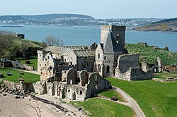
The Outer Line ran from a gun battery at Kinghorn to a battery at Leith Docks, with fortified gun emplacements on the island of Inchkeith. The Middle Line of defence ran from Braefoot Battery in the North to a battery on Cramond Island in the South, with fortified gun emplacements on the islands of Inchcolm and Inchmickery. The Inner Line of defence was situated close to the Forth Bridge, with batteries at Downing Point on the North coast and Hound Point on the South coast of the river. Additional batteries were located at Carlingnose Point, Dalmeny, and on the island of Inchgarvie. Each line of defence also had an associated anti-submarine boom.

1. Battery specification

The Braefoot Battery was equipped with two large calibre naval gun emplacements, designed to engage any large enemy surface vessels threatening ships at anchor in the Firth of Forth and the naval facilities at Rosyth Dockyard. Each gun emplacement housed a BL 9.2-inch Mk IX – X naval gun which could fire a shell weighing 55 kg out to range of 26 km. The battery was manned by local men of the Territorial Royal Garrison Artillery The coast guns were such an important part of the defence of the country that considerable efforts were made to protect them from landings of enemy troops that might put them out of action. The battery had a defended perimeter comprising, from inside out, a firing trench, a 10 foot high 'palisade' fence, and a barbed wire entanglement. The barrack building was heavily fortified and the outward facing side contained firing loop holes. The site was also surrounded by a ring of six blockhouses inland and along the shore.

1. History

According to official records, approval had been given before the war for the construction of a battery of 9.2-inch guns at Braefoot and formal plans were drawn up by the War Office in 1912. Authority to proceed with construction was given in July 1914 and orders were placed for the guns, carriages and other equipment. Mounting pedestals for the guns arrived at Aberdour Station in January 1915 however they did not reach the battery until May. The two guns were mounted on 28 May and 6 July 1915. Later in the war the fleet anchorages moved East of the Forth Bridge and consequently the defensive lines were also moved Eastwards. It was suggested that the guns be removed to the battery at Kinghorn, but permission for this was not given. However, in October 1917 the guns were ordered to be dismounted and stored ready for reallocation – with one gun sent to Portsmouth in December.

1. Current status

Today much of the Braefoot Battery remains and can be accessed by the public. The battery site, and the clear view over the River Forth from the gun emplacements, is now obstructed by a post war woodland plantation. Braefoot Plantation is owned by ExxonMobil who operate the adjacent LPG Tanker Terminal but public access is permitted through the Scottish Outdoor Access Code. The location is popular with walkers and a substantial (but unofficial) mountain bike trail has been constructed in the surrounding woodland. Although the actual guns are now long gone, the gun emplacements and all of the battery buildings are still present (although now bricked up for public safety). Grid references for surviving battery structures include:

NT 17877 83404/NT 17905 83439 Gun Emplacements NT 17878 83493 Magazine and Tramway NT 17929 83523 Observation Post NT 17935 83543 Building NT 17799 83466 Barracks; Workshops NT 17914 83482 Observation Post NT 17710 83128 Pier

1. See also

Firth of Forth Downing Point Battery Coastal fortifications in Scotland

1. References
Nearby Places View Menu
Location Image
959 m

St Bridget's Kirk

St. Bridget's Kirk is a ruined church on the outskirts of Dalgety Bay, Fife, Scotland. It is a shell of a medieval church, dating back at least as far as 1178, and was altered in the 17th century for Protestant worship. It has been a ruin since the 19th century.
Location Image
1.3 km

Inchcolm Abbey

Inchcolm Abbey is a medieval abbey located on the island of Inchcolm in the Firth of Forth in Scotland. The Abbey, which is located at the centre of the island, was founded in the 12th century during the episcopate of Gregoir, Bishop of Dunkeld. Later tradition placed it even earlier, in the reign of King Alexander I of Scotland (1107–24), who had taken shelter on Incholm when his ship was forced ashore during a storm in 1123. It is said he resided there for three days with the Hermit of Incholm. The Abbey was first used as a priory by Augustinian canons regular, becoming a full abbey in 1235. The island was attacked by the English from 1296 onwards, and the Abbey was abandoned as a result of the Scottish Reformation in 1560. It has since been used for defensive purposes, as it is situated in a strategically important position in the middle of the Firth of Forth. A Latin inscription carved above the Abbey's entrance reads: Stet domus haec donec fluctus formica marinos ebibat, et totum testudo perambulet orbem Translated, it has been rendered thus: "Still may these turrets lift their heads on high, Nor e’er as crumbling ruins strew the ground, Until an ant shall drink the ocean dry, And a slow tortoise travel the world round." Inchcolm Abbey has the most complete surviving remains of any Scottish monastic house. The cloisters, chapter house, warming house, and refectory are all complete, and most of the remaining claustral buildings survive in a largely complete state. The least well-preserved part of the complex is the monastic church. The ruins are cared for by Historic Environment Scotland, which also maintains a visitor centre near the landing pier (entrance charge; ferry from South Queensferry). In July 1581 stones from the abbey were taken to Edinburgh to repair the Tolbooth. Among the Abbots of Inchcolm was the 15th-century chronicler Walter Bower.
Location Image
1.5 km

Inchcolm

Inchcolm (from Scottish Gaelic Innis Choluim 'Columba's Island') is an island in the Firth of Forth in Scotland. The island has a long history as a site of religious worship, having started with a church, which later developed into a monastery and a large Augustine Abbey in the mid 13th century. It was repeatedly attacked by English raiders during the Wars of Scottish Independence, and was later fortified extensively with gun emplacements and other military facilities during both World Wars to defend nearby Edinburgh. Inchcolm Abbey and the surrounding island are now in the care of Historic Scotland. The island is accessible to visitors during the day via private boat tours from Queensferry. Many of the religious buildings on Inchcolm remain in fair condition and Inchcolm is described as having the best-preserved cloister in Scotland.
1.9 km

RNAS Donibristle

Royal Naval Air Station Donibristle or more simply RNAS Donibristle was a former Fleet Air Arm base located 2.7 miles (4.3 km) east of Rosyth, Fife, and 8.7 miles (14.0 km) northwest of Edinburgh. It was also known as HMS Merlin. It grew from an emergency landing ground first established in 1917 on the Earl of Moray's Donibristle Estate by 77 Sqn of the Royal Flying Corps and was transferred to Royal Naval Air Service control in September 1917 becoming a RNAS Aircraft Repair Depot. On 1 April 1918 the Royal Naval Air Service merged with the Royal Flying Corps to create the Royal Air Force and Donibristle became a RAF Station between 1918 and 1939 operated by the Fleet Air Arm as part of RAF Coastal Area and later Coastal Command. During the interbellum Donibristle was an important centre of training for torpedo bomber crews with a number of new squadrons forming at the airfield. On 24 May 1939, control of the Fleet Air Arm was returned to the Royal Navy and the airfield was renamed Royal Naval Air Station Donibristle (HMS Merlin). In addition to being an important shore base for training and disembarked naval aircraft units, a substantial Royal Naval Aircraft Repair Yard was developed in the North West corner of the airfield which employed a large civilian workforce alongside naval personnel. Over 7,000 aircraft were repaired and maintained at Donibristle during the Second World War. Post war, Fleet Air Arm activity at Donibristle slowed considerably and HMS Merlin was eventually run down and paid off by the Royal Navy in November 1953. The Royal Naval Aircraft Yard continued to operate under the civilian contracted management of Airwork Ltd until April 1959 at which point the airfield site was completely closed. The land was sold to developers who created the Hillend and Donibristle Industrial Estates and the new town of Dalgety Bay. The first residents moved in to Dalgety Bay on 28 October 1965.