
 English
 Français

Hawk Inn, Haslington
The Hawk Inn is a Grade II listed public house at 137 Crewe Road, Haslington, Cheshire, CW1 5RG. It is on the Campaign for Real Ale's National Inventory of Historic Pub Interiors. It was built in the early 16th century.
1. See also
Listed buildings in Haslington
1. References
Lieux à Proximité Voir Menu

129 m
St Matthew's Church, Haslington
St Matthew's Church is in the village of Haslington, Cheshire, England. The church is recorded in the National Heritage List for England as a designated Grade II listed building. It is an active Anglican parish church in the diocese of Chester, the archdeaconry of Macclesfield and the deanery of Nantwich. Its benefice is combined with that of St Michael and All Angels, Crewe Green.
460 m
Haslington
Haslington is a village and civil parish in the unitary authority of Cheshire East and the ceremonial county of Cheshire, England. It lies about 2 miles (3.2 km) north-east of the much larger railway town of Crewe and approximately 4 miles (6.4 km) south of Sandbach. The village was originally bisected by the A534 road that links Crewe with Sandbach, however, this road has now been re-routed to bypass the village to the north-west. The village is also a close neighbour to a number of small towns and villages (including Alsager, Wheelock, Winterley), and is approximately 6 miles (9.7 km) from the Elizabethan market town of Nantwich. The village lies approximately 11 miles (18 km) north-west of the Staffordshire Potteries .
1.1 km
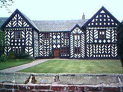
Haslington Hall
Haslington Hall is a country house located in open countryside 1 km east of the village of Haslington, Cheshire, England. It is recorded in the National Heritage List for England as a designated Grade I listed building.

1.3 km
Crewe Green
Crewe Green is a small village and former civil parish, now in the parish of Weston and Crewe Green, in the unitary authority area of Cheshire East and the ceremonial county of Cheshire, England. The village lies 1½ miles to the east of the centre of Crewe. The parish also includes a dispersed settlement of houses and farms called Slaughter Hill, the Jacobean mansion of Crewe Hall, and the industrial estates of Crewe Hall Enterprise Park and Crewe Hall Farm. Nearby villages include Haslington and Stowford.
According to the 2001 census, the parish had a population of 140, increasing to 213 at the 2011 Census.