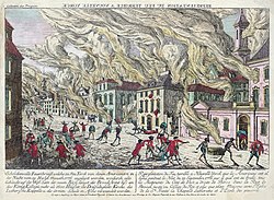
The Great Fire of New York was a devastating fire that burned through the night of September 20, 1776, and into the morning of September 21, on the West Side of what then constituted New York City at the southern end of the island of Manhattan. It broke out in the early days of the military occupation of the city by British forces during the American Revolutionary War. The fire destroyed from 10 to 25 percent of the buildings in the city, while some unaffected parts of the city were plundered. Many people believed or assumed that one or more people deliberately started the fire for a variety of different reasons. British leaders accused revolutionaries acting within the city and state, and many residents assumed that one side or the other had started it. The fire had long-term effects on the British occupation of the city, which did not end until 1783.

Nearby Places View Menu
Location Image
25 m

Whitehall Street

Whitehall Street is a street in the South Ferry/Financial District neighborhood of Lower Manhattan in New York City, near the southern tip of Manhattan Island. The street begins at Bowling Green to the north, where it is a continuation of the southern end of Broadway. Whitehall Street stretches four blocks to the southern end of FDR Drive, adjacent to the Staten Island Ferry's Whitehall Terminal, on landfill beyond the site of Peter Stuyvesant's 17th-century house. Whitehall Street is one of New York's oldest streets, having been a 17th-century road in the Dutch colony of New Amsterdam. It was known as Marckvelt by 1658 and as Whitehall Street by 1731. Over the years, the street has been widened and modified to accommodate different traffic patterns. Whitehall Street contains several structures, including the Alexander Hamilton U.S. Custom House and 2 Broadway at its northern end. The street has entrances to the New York City Subway's Whitehall Street–South Ferry station at both its ends, as well as the Staten Island Ferry terminal and Battery Maritime Building at its southern end.
56 m

Bridge Street (Manhattan)

Bridge Street is a street in the Financial District of Lower Manhattan in New York City, running two blocks from State Street in the west to Broad Street in the east. It intersects Whitehall Street.
Location Image
65 m

2 New York Plaza

125 Broad Street (formerly known as 2 New York Plaza) is an office building in the Financial District of Manhattan in New York City, at the intersection of Broad Street and South Street near South Ferry. The building, standing 504 feet (154 m) tall with 40 floors, is one of the southernmost skyscrapers in Lower Manhattan. The building was designed by the Kahn & Jacobs architecture firm, and developed by Sol Atlas and John P. McGrath. Construction took place from 1970 to 1971. The building is to the east of 1 New York Plaza, and to the south of 55 Water Street. It has a modern structural design, and is one of a series of modern-style buildings built in the Financial District during the 1960s and 1970s. Starting in 2007 the managers began incorporating energy saving renovations to meet LEED Silver standards. Building amenities include on-site management, day care, a coffee shop, shoe shine and a 50-car garage.
Location Image
65 m

South Ferry/Whitehall Street station

The South Ferry/Whitehall Street station is a New York City Subway station complex in the Financial District neighborhood of Manhattan, under Battery Park. The complex is shared by the IRT Broadway–Seventh Avenue Line and the BMT Broadway Line. It is served by the 1 and R trains at all times, the W train only on weekdays during the day, and the N train at night. It is the southern terminal for all 1 and W trains and the northern terminal for late night R trains. The complex originally consisted of three separate stations. In 1905, the Interborough Rapid Transit Company (IRT) opened a balloon loop at South Ferry, serving the IRT Broadway–Seventh Avenue and IRT Lexington Avenue Lines. The Brooklyn–Manhattan Transit Corporation (BMT) opened its station at Whitehall Street in 1918. The same year, the IRT opened a second loop for the IRT Lexington Avenue Line on the inside of the existing loop; the two loop stations were not connected to each other nor to the BMT station. Despite their proximity, the stations remained separate for 91 years. In the early 2000s, as part of the recovery effort from the September 11, 2001, attacks, a new South Ferry terminal for the Broadway–Seventh Avenue Line was proposed. That station opened in 2009, replacing the loop station and providing a connection between the Broadway–Seventh Avenue Line's 1 train and the Broadway Line's N, R, and W trains. The new terminal for the Broadway–Seventh Avenue Line was severely damaged during Hurricane Sandy in 2012, and the MTA temporarily re-opened the loop station between 2013 and 2017, adding a temporary connection between the IRT Broadway–Seventh Avenue Line's loop and the BMT Broadway Line's platforms. The newer terminal reopened in June 2017 following extensive renovations and waterproofing work. This station complex is the third on the site to bear the name South Ferry. The first was an elevated station located nearby, which was open from 1877 to 1950 and served the former IRT Ninth, Sixth, Third, and Second Avenue elevated lines. The second was the old South Ferry loop station, located above the existing station complex.