
 English
 Français
Stalybridge South (ward)
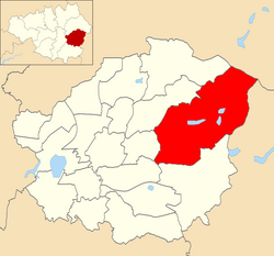
Stalybridge South is an electoral ward of Tameside, England. It is represented in Westminster by Jonathan Reynolds Labour Co-operative MP for Stalybridge and Hyde.
Nearby Places View Menu

691 m
Harridge Pike
Harridge Pike is a hill situated within the boundaries of Stalybridge, Greater Manchester just outside the Peak District National Park. Its western flank rises from the valley of the River Tame to a height of 395 metres. To the east, the pike falls away more gradually to Swineshaw Moor which, above the Swineshaw reservoirs, rises to Irontongue Hill, a broad shoulder of Hoarstone Edge. Since 2004, the moorland in the area of the pike has been classed as access land. From the summit of Harridge Pike, a view is afforded of the middle section of the Tame valley and the whole of the town of Stalybridge, large swathes of the eastern suburbs of Manchester and beyond to Manchester city centre, where its town hall is visible. On exceptionally clear days the mountains of Snowdonia are visible.

777 m
Lower Swineshaw Reservoir
Lower Swineshaw Reservoir is the second reservoir from the top of a series of four in the Brushes valley above Stalybridge in Greater Manchester. It was built in the 19th century to supply safe drinking water. It is owned and operated by United Utilities.
The reservoir dam consists of a clay core within an earth embankment.

1.0 km
Higher Swineshaw Reservoir
For the reservoirs near Glossop, in Derbyshire, see Upper Swineshaw Reservoir and Swineshaw Reservoir (Derbyshire)
Higher Swineshaw Reservoir is the highest reservoir in a series of four in the Brushes valley above Stalybridge in Greater Manchester. It was built in the 19th century to provide a supply of safe drinking water. Though the reservoir and its watershed are totally in Greater Manchester it is within a mile of the Derbyshire border. It is owned and operated by United Utilities.
The reservoir dam consists of a clay core within an earth embankment. The Peak District Boundary Walk runs across the dam on the south side of the reservoir.

1.8 km
Carrbrook
Carrbrook is a village east of Stalybridge, in Greater Manchester, England. Historically part of Cheshire, the area still has many seventeenth and eighteenth-century buildings. Much of the late-nineteenth and the early-twentieth-century village was built during the industrial boom brought by the printworks. In the 1970s modern Housing estates were built next to the old village on the lower flank of Harridge Pike. The view to the east of Carrbrook is dominated by the steep-sided Buckton Hill, on the summit of which is located Buckton Castle. Neighbouring communities include Millbrook, Heyheads and Mossley.
Many properties in Carrbrook were threatened by a large wildfire burning on Buckton Moor in late June 2018. The fires burned for several weeks and the damage caused is still visible to this day. On 26 June 2018, 50 properties in Carrbrook were evacuated as the fire advanced towards the settlement. Carrbrook is now part of a high fire risk zone.
On 27 December 2023 at approx. 23:10 GMT, a tornado hit the village during Storm Gerrit - the strongest in the UK since 2006. Heavy damage was done to some structures, however no deaths were recorded.