
 English
 Français

Wellington, Cumbria
Wellington is a small village in the civil parish of Gosforth, Cumberland, Cumbria, England, lying north east of Gosforth beside the River Bleng A bridge at Wellington carries the Gosforth to Wasdale road over the river. Hall Croft, Wellington, is a late 18th- or early 19th-century house and a grade II listed building.
Nearby Places View Menu

673 m
St Mary's Church, Gosforth
St Mary's Church in the village of Gosforth, Cumbria, England, is an active Anglican parish church in the deanery of Calder, the archdeaconry of West Cumberland, and the diocese of Carlisle. Its benefice is united with those of St Olaf, Wasdale Head, and St Michael, Nether Wasdale. The church is recorded in the National Heritage List for England as a designated Grade I listed building. It is associated with "a unique Viking-age assemblage" of carved stones.

681 m
Gosforth Cross
The Gosforth Cross is a large stone monument in St Mary's churchyard at Gosforth in the English county of Cumbria, dating to the first half of the 10th century AD. Formerly part of the kingdom of Northumbria, the area was settled by Scandinavians some time in either the 9th or 10th century. It has gained reputation for its combination of Christian symbols with Nordic symbols, being a tangible piece of evidence of the impact of the Christianization of Scandinavia.
The deities depicted on the monument have been identified with Sigyn attempting to protect her bound husband Loki, a horn-wielding Heimdallr, Víðarr in the process of defeating Fenrir, and Thor in a failed attempt to capture Jörmungandr. The images likely adapt scenes from the Poetic Edda. Also depicted on the monument is the crucifixion of Jesus. The tree-like design of the base of the cross may represent Yggdrasil or a mythical tree of life.
847 m
Gosforth, Cumbria
Gosforth is a village, civil parish and electoral ward in the Lake District, in Cumberland, England. It is situated on the A595 road between Whitehaven and Barrow-in-Furness. It had a population of 1,230 at the 2001 Census. At the 2011 census Gosforth was grouped with Ponsonby and Wasdale giving a total population of 1,396.
Adjacent settlements include Whitehaven, Egremont, Ravenglass and Wasdale. It is close to Wast Water, the deepest lake in England, and just a 7-minute drive from Seascale village and beach. The Cumbrian Coast railway can be accessed at Seascale.
2.4 km
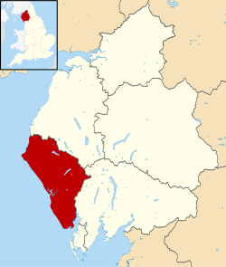
Borough of Copeland
The Borough of Copeland was a local government district with borough status in western Cumbria, England. Its council was based in Whitehaven. It was formed on 1 April 1974 by the merger of the Borough of Whitehaven, Ennerdale Rural District and Millom Rural District. The population of the Non-Metropolitan district was 69,318 according to the 2001 census, increasing to 70,603 at the 2011 Census.
The name was derived from an alternative name for the Cumberland ward of Allerdale above Derwent, which covered roughly the same area.
There are different explanations for the name. According to a document issued at the time of the borough's grant of arms, the name is derived from kaupland, meaning "bought land," referring to an area of the Forest bought from the estate of St Bees Priory.
In July 2021 the Ministry of Housing, Communities and Local Government announced that in April 2023, Cumbria would be reorganised into two unitary authorities. On 1 April 2023, Copeland Borough Council was abolished and its functions were transferred to the new unitary authority Cumberland, which also covers the former districts of Allerdale and Carlisle.