
 English
 Français

Grindale
Grindale est une paroisse civile et un village du Yorkshire de l'Est, en Angleterre.
Nearby Places View Menu
0 m
Grindale
Grindale is a village and civil parish in the East Riding of Yorkshire, England. It is situated approximately 4 miles (6 km) north-west of Bridlington town centre.
The name Grindale derives from the Old English grēnedæl meaning 'the green dale'.
The village has an airstrip, which is used predominantly for skydiving. It is currently operated by Skydive GB Parachute Club, an approved dropzone of the British Parachute Association.
According to the 2001 UK Census, Grindale parish had a population of 98, however the 2011 census grouped the parish with Boynton (2001 pop. 161), giving a total of 229.
In 1823 Grindale (then Grindall), was in the civil parish of Bridlington, the Wapentake of Dickering, and the Liberty of St Peter's. Population at the time was 107, which included six farmers and the parish curate.
Between 1894 and 1974 Grindale was a part of the Bridlington Rural District, in the East Riding of Yorkshire. Between 1974 and 1996 it was part of the Borough of North Wolds (later Borough of East Yorkshire), in the county of Humberside.

3.0 km
Speeton railway station
Speeton railway station served the villages of Speeton and Reighton in North Yorkshire, England. It was situated on the Yorkshire Coast Line from Scarborough to Hull and was opened on 20 October 1847 by the York and North Midland Railway. It closed on 5 January 1970. The station building and the adjacent platform are still in place.

3.1 km
Boynton, East Riding of Yorkshire
Boynton is a village and civil parish in the East Riding of Yorkshire, England. It is approximately 3 miles (5 km) west of the town of Bridlington and lies on the B1253 road.
According to the 2001 UK census, the parish had a population of 161. However the 2011 census grouped the parish with Grindale (2001 pop. 98), giving a total of 229.
The parish church of St Andrew is a Grade I listed building. It includes a 15th-century tower, as well as memorials to the
Strickland, later Cholmley, later Strickland-Constable Baronets, of Boynton (1641), whose seat was Boynton Hall, which is also Grade I listed.
The name Boynton derives from the Old English Bofaingtūn meaning 'settlement connected with Bofa'.
From the mediaeval era until the 19th century Boynton was part of Dickering Wapentake. Between 1894 and 1974 Boynton was a part of the Bridlington Rural District, in the East Riding of Yorkshire. Between 1974 and 1996 it was part of the Borough of North Wolds (later Borough of East Yorkshire), in the county of Humberside.
3.5 km
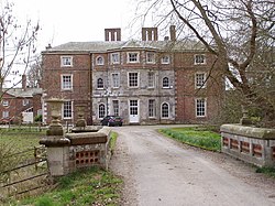
Boynton Hall
Boynton Hall is a country house in the village of Boynton near Bridlington, East Riding of Yorkshire, England. It is a Grade I listed building.
Originally constructed in the late 16th century, the house has been remodelled several times. It is built in red brick with stone dressings and a slate roof, originally to an H-shaped plan, but since infilled at the front. Originally a two-storey building, it is now a three-storey building with a 7-bay frontage. The central 5 bays project slightly and have a 3-window polygonal bay.
The Hall stands within an associated park, whose features include a walled garden and the Carnaby Temple folly (known locally as the Pepperpot). Other buildings, such as the Dairy, the Pigeon House, and the Lodge, are Grade II listed buildings.

3.8 km
Speeton
Speeton is a village in the civil parish of Reighton, in North Yorkshire, England. It lies near the edge of the coastal cliffs midway between Filey and Bridlington. It is North Yorkshire's easternmost settlement, but historically lay in the East Riding of Yorkshire until local government re-organisation in 1974. From 1974 to 2023 it was part of the Borough of Scarborough, it is now administered by the unitary North Yorkshire Council.
Speeton was formerly a township and chapelry in the parish of Bridlington, in 1866 Speeton became a separate civil parish, on 1 April 1935 the parish was abolished and merged with Reighton. In 1931 the parish had a population of 165.
Speeton railway station on the Yorkshire Coast Line from Hull to Scarborough served the village until it closed on 5 January 1970.
A local geological feature, the Speeton Clay Formation (approximately 130 million years old), was the source of an especially interesting fossil of a hermit crab.
The name Speeton derives from the Old English spēctūn meaning 'speech settlement', possibly referring to council meetings being held here.