
 English
 Français
Fosse Kellingley
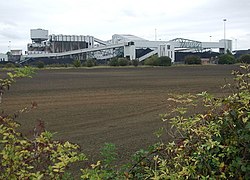
Kellingley (Kellingley Colliery en anglais) est une houillère faisant partie du bassin houiller du Yorkshire-Nottinghamshire, située dans le comté anglais du Yorkshire du Nord, à deux kilomètres à l'est de Knottingley. Appartenant à l'entreprise privée UK Coal, il s'agissait de la dernière mine souterraine de Grande-Bretagne à être encore en activité du début du XXIe siècle jusqu'à sa fermeture définitive le 18 décembre 2015.
Nearby Places View Menu
0 m
Kellingley Colliery
Kellingley Colliery, known affectionately as the 'Big K', was a deep coal mine in North Yorkshire, England, 3.6 miles (5.8 km) east of Ferrybridge power station. It was owned and operated by UK Coal.
The colliery closed on 18 December 2015, marking the end of deep-pit coal mining in Britain. The site is earmarked for commercial development.

1.7 km
Mary Towneley Loop
The Mary Towneley Loop is a 47-mile (76 km) circular route that forms part of the Pennine Bridleway National Trail, along the borders of Lancashire and Yorkshire. The loop was opened in 2002, the first section of the Pennine Bridleway.
It is named in memory of Mary, Lady Towneley, who drew attention to the poor state of England's bridleways and the need for a long-distance route for horse-riders by riding with two friends in September 1986 from Hexham in Northumberland to Ashbourne in Derbyshire. She died in 2001.
The route joins the main Pennine Bridleway at two points, one near the village of Summit between Littleborough and Todmorden, and one just east of Worsthorne. Heading west from Summit the Loop climbs to Top of Leach at 474 metres (1,555 ft). The trail then passes through the town of Waterfoot in the Rossendale Valley and follows new tracks via Lumb before entering the Cliviger Gorge and then climbing up to the Long Causeway. It then heads north to rejoin the main Pennine Bridleway just east of Worsthorne. The Loop then follows the main route to enter West Yorkshire at Widdop, crosses Heptonstall Moor and drops down to cross the Calder Valley just west of the town of Hebden Bridge. The trail passes the villages of Mankinholes and Bottomley to return to Summit.
An annual relay race, organized by Rossendale Harriers, took place in late January or early February until 2011. Teams consisting of five pairs of runners race over five relay legs completed the entire 47 miles and 6,400 feet of ascent of the loop, clockwise from Fearns Sports College in Stacksteads. The last race in 2011 took place on 30 January and hosted 109 teams, 1,090 individual runners from clubs across the north of England, and was won by Salford Harriers.

2.1 km
Cridling Stubbs
Cridling Stubbs is a village and civil parish in North Yorkshire. It is near the town of Knottingley. In 2011 it had a population of 152.
The village was historically part of the West Riding of Yorkshire until 1974. From 1974 to 2023 it was part of the district of Selby, it is now administered by the unitary North Yorkshire Council.
A Romano-British hoard of 3,330 coins in a jar (the Cridling Stubbs Hoard) dating to the 4th century AD was found near the village in 1967.

2.1 km
Beal, North Yorkshire
Beal is a village and civil parish in North Yorkshire, England. It is situated on the River Aire, 3.5 miles (6 km) north-east of Knottingley, 8 miles (13 km) south-west of Selby, and 21 miles (34 km) south of York. The parish includes the village of Kellingley, and borders the City of Wakefield in West Yorkshire. At the 2001 census it had a population of 720, increasing to 738 at the 2011 census.

2.2 km
Kellington Windmill
Kellington Windmill is a historic building in Kellington, a village in North Yorkshire, in England.
The windmill was built in about 1800, to grind corn. It originally had four floors and was powered solely by wind, but a paraffin engine was added so it could be used during calm periods, and after the First World War the sails were no longer in use. Milling ended in 1927, and the building was disused until the Second World War, when it was used as a look out post by the Home Guard. It was converted into a house, but then became derelict. For a short time it was used to grow mushrooms, but was then reconverted into a house.
The windmill was grade II listed in 1987. It is built of magnesian limestone with some rendering and brick infill. It contains doorways and casement windows, all under segmental arches. It originally had a cap, which is now missing.