
 English
 Français
Thorpe Salvin
Thorpe Salvin est un village et une paroisse civile du Yorkshire du Sud, en Angleterre.
Nearby Places View Menu

0 m
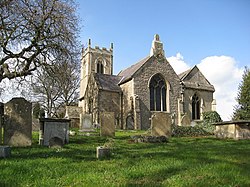
Thorpe Salvin
Thorpe Salvin is a village and a civil parish in the Metropolitan Borough of Rotherham in South Yorkshire, England, on the border with Nottinghamshire. It lies between Worksop and Harthill, and is located at an elevation of around 110 metres above sea level. At the 2011 Census, it had a population of 476, down from 502 in 2001.
The rectangular-towered parish church of St Peter, a predominantly 12th-century structure with 15th-century additions, is emblazoned with Norman carvings, and has been nominated among England's 1,000 best churches. It was Grade I listed in 1966. The village has a public house, the Parish Oven.

927 m
Harry Crofts Colliery
Harry Crofts Colliery was a small, short lived coal mine within the parish of South Anston, near Rotherham, South Yorkshire.
The colliery was sunk between 1924 and 1926 and closed in 1930. It was situated about two miles east of Kiveton Park railway station and was on the north side of the main line of the L.N.E.R. almost at the junction of the west curve to the
Great Central and Midland Joint Railway at Brantcliffe West Junction. This line was closed before the colliery opened and was used for wagon storage into the 1960s.

2.0 km
Kiveton Park railway station
Kiveton Park railway station is a station in South Anston, South Yorkshire, England. The original station was opened by the Sheffield and Lincolnshire Junction Railway in 1849, situated to the east of the level crossing and opened with the line. It was rebuilt in the Manchester, Sheffield and Lincolnshire Railway "Double Pavilion" style in 1884, on the west side of the level crossing.
Despite its name, the closest station to the village of Kiveton Park is the neighbouring Kiveton Bridge station.
Kiveton Park was a centre of lime working in the area, and many company sidings came under the jurisdiction of its Station Master. Adjacent to the station was the Dog Kennels Lime and Stone Works, named after the road linking the station to Anston, and the Kiveton Park Lime and Stone Works. Just to the east were the Kiveton Park and Anston lime quarries. All the companies had lime burning facilities and agricultural lime was supplied, by rail, to outlets in Lincolnshire. Kiveton Park Colliery was located to the west of the station, and was rail-connected until its closure in 1994.
Along with neighbouring Kiveton Bridge station, it was completely rebuilt during the early 1990s with modern platforms, lighting and waiting shelters, this work being funded by the South Yorkshire Passenger Transport Executive. The only remaining part of the 1884 station is the Station Master's house (now privately owned) which stands on the Sheffield-bound (down) platform. It is now unstaffed (all tickets must be purchased on the train or prior to travel), with train running details provided by display screens, telephone and timetable poster boards. Step-free access is available to both platforms from the adjacent level crossing (which is still operated from the adjacent signal box).
Severe damage was caused to the embankment and tracks near here during the widespread flooding in 2007. Repairs cost over £1 million, and the line was closed for several weeks whilst the embankment was rebuilt and the tracks relaid.

2.2 km
Anston Stones Wood
Anston Stones Wood (grid reference SK531831) is a 33.7 hectare (88.3 acre) biological site of Special Scientific Interest in South Yorkshire. The site was notified in 1955. The site contains the second best example of limestone woodland in South Yorkshire. It is also a Local Nature Reserve.

2.5 km
St James Church, Anston
St James Church, Anston is a grade I listed Church of England parish church situated in Anston, South Yorkshire, England.