
 English
 Français
Kilham (Yorkshire de l'Est)
Kilham est une paroisse civile et un village du Yorkshire de l'Est, en Angleterre.
1. Notes et références
(en) Cet article est partiellement ou en totalité issu de l’article de Wikipédia en anglais intitulé « Kilham, East Riding of Yorkshire » (voir la liste des auteurs).
1. Liens externes
Ressource relative à la géographie : Open Domesday
Portail du Yorkshire
Nearby Places View Menu
0 m
Kilham, East Riding of Yorkshire
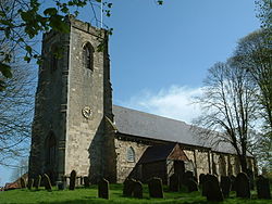
Kilham is a village and civil parish in the East Riding of Yorkshire, England. It is situated about 5 miles (8 km) north-east of Driffield town centre. According to the 2011 UK census, Kilham parish had a population of 1,088, an increase on the 2001 UK census figure of 1,010.

2.5 km
Ruston Parva
Ruston Parva is a hamlet and former civil parish, now in the parish of Harpham, in the East Riding of Yorkshire, England. It is situated approximately 8 miles (13 km) south-west of Bridlington and lies just north of the A614. In 1931 the parish had a population of 84. On 1 April 1935 the parish was abolished and merged with Harpham.
The name Ruston derives from either the Old Norse personal name Hror or the Old English personal name Roarr, and the Old English tūn meaning 'settlement'.
In the Domesday Book of 1086 the village is written as Roreston, and in 1066 and 1086 lordship of the manor was held by the Canons of the Church of St John, Beverley.
Evidence of medieval occupation has been recorded in the village though observations of earthworks, indicating ridge and furrow field systems, enclosures and a hollow way. In 1968 ditch remains of a moat were observed at the south of the village. The moat may have been part of Upper House manor house.
Ruston Parva's Grade II* listed Anglican church is dedicated to Saint Nicholas. It was built in Norman style in 1832 from ashlar and yellow brick, and has a tower supported inside by cast iron pillars. Its two deck pulpit and box pews also probably date from 1832.
Leeds-based band the Kaiser Chiefs originally named themselves Runston Parva after the East Riding of Yorkshire village.

3.0 km
Dickering Wapentake
Dickering was a wapentake (which is an administrative division) of the historic East Riding of Yorkshire in England, consisting of the north-east part of that county, including the towns of Bridlington and Filey; its territory is now partly in the modern East Riding and partly in North Yorkshire. It was established in 12th or 13th century by combining the three ancient Domesday hundreds of Burton, Huntou (Hunthow) and Torbar. The Wapentake of Dickering ceased to have much significance in the 19th century when the wapentakes were superseded by other administrative divisions for most local government purposes.
Dickering consisted of the parishes of Argam, Bempton, Bessingby, Boynton, Bridlington, Burton Agnes, Burton Fleming, Carnaby, Flamborough, Folkton, Foston on the Wolds, Foxholes, Ganton, Garton on the Wolds, Hunmanby, Kilham, Langtoft, Lowthorpe, Muston, Nafferton, Reighton, Rudston, Ruston Parva, Thwing, Willerby and Wold Newton, and part of the parish of Filey.

3.6 km
Rudston Roman villa
Rudston Roman villa is a Romano-British villa and scheduled monument near Rudston, East Riding of Yorkshire, England.

4.0 km
Harpham
Harpham is a small village and civil parish in the East Riding of Yorkshire, England. It is located just south of the A614 road, approximately 5 miles (8 km) north-east of Driffield and 7 miles (11 km) south-west of Bridlington.
The civil parish is formed by the village of Harpham and the hamlets of Lowthorpe and Ruston Parva. According to the 2011 UK census, Harpham parish had a population of 303, a decline on the 2001 UK census figure of 318.