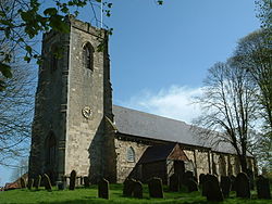
Ruston Parva is a hamlet and former civil parish, now in the parish of Harpham, in the East Riding of Yorkshire, England. It is situated approximately 8 miles (13 km) south-west of Bridlington and lies just north of the A614. In 1931 the parish had a population of 84. On 1 April 1935 the parish was abolished and merged with Harpham. The name Ruston derives from either the Old Norse personal name Hror or the Old English personal name Roarr, and the Old English tūn meaning 'settlement'. In the Domesday Book of 1086 the village is written as Roreston, and in 1066 and 1086 lordship of the manor was held by the Canons of the Church of St John, Beverley. Evidence of medieval occupation has been recorded in the village though observations of earthworks, indicating ridge and furrow field systems, enclosures and a hollow way. In 1968 ditch remains of a moat were observed at the south of the village. The moat may have been part of Upper House manor house. Ruston Parva's Grade II* listed Anglican church is dedicated to Saint Nicholas. It was built in Norman style in 1832 from ashlar and yellow brick, and has a tower supported inside by cast iron pillars. Its two deck pulpit and box pews also probably date from 1832. Leeds-based band the Kaiser Chiefs originally named themselves Runston Parva after the East Riding of Yorkshire village.

Lieux à Proximité Voir Menu
Location Image
2.3 km

Lowthorpe

Lowthorpe is a village and former civil parish, now in the parish of Harpham, in the East Riding of Yorkshire, England. It is situated approximately 3 miles (5 km) north-east of Driffield town centre and 7 miles (11 km) south-west of Bridlington town centre. In 1931 the parish had a population of 159. On 1 April 1935 the parish was abolished and merged with Harpham. It lies south-east of the A614 road and just north-west of the Yorkshire Coast railway line from Hull to Scarborough. Lowthorpe railway station served the village until it closed on 5 January 1970. The name Lowthorpe derives from the Old Norse Lagiþorp or Logiþorp meaning 'Lagi's' or 'Logi's secondary settlement'. The church dedicated to St Martin was designated a Grade II* listed building in 1966 and is now recorded in the National Heritage List for England, maintained by Historic England. In 1823 Lowthorpe (then spelt 'Lowthorp'), was in the Wapentake of Dickering. The church and perpetual curacy was under the patronage of the St Quintin family. Population at the time was 149, with occupations including nine farmers, a linen manufacturer, a corn miller, and a rope maker. Residents included William Thomas St Quintin Esquire, of Lowthorp Hall, and a gentleman.
Location Image
2.5 km

Kilham, East Riding of Yorkshire

Kilham is a village and civil parish in the East Riding of Yorkshire, England. It is situated about 5 miles (8 km) north-east of Driffield town centre. According to the 2011 UK census, Kilham parish had a population of 1,088, an increase on the 2001 UK census figure of 1,010.
Location Image
2.6 km

Nafferton

Nafferton is a village and civil parish in the East Riding of Yorkshire, England. It is situated approximately 2 miles (3.2 km) north-east of Driffield town centre and lies just south of the A614 road. The village is served by Nafferton railway station on the Yorkshire Coast Line from Hull to Scarborough. According to the 2011 UK Census, Nafferton parish had a population of 2,433, an increase on the 2001 UK Census figure of 2,184.
Location Image
2.8 km

Harpham

Harpham is a small village and civil parish in the East Riding of Yorkshire, England. It is located just south of the A614 road, approximately 5 miles (8 km) north-east of Driffield and 7 miles (11 km) south-west of Bridlington. The civil parish is formed by the village of Harpham and the hamlets of Lowthorpe and Ruston Parva. According to the 2011 UK census, Harpham parish had a population of 303, a decline on the 2001 UK census figure of 318.