
 English
 Français

Hemingbrough
Hemingbrough est un village et une paroisse civile du Yorkshire du Nord, en Angleterre.
Nearby Places View Menu
297 m
Hemingbrough
Hemingbrough is a village and civil parish in North Yorkshire, England, approximately 5 miles (8 km) from Selby and 4 miles (6.4 km) from Howden on the A63. It was in the historic East Riding of Yorkshire, but since 1974 has come under North Yorkshire. The village has a 12th-century former collegiate church (Hemingbrough Minster), a Methodist chapel and shops. There is a primary school and nursery. The surrounding area makes up part of the Humberhead Levels and is flat land, mainly used for mixed agriculture. In 2011 the parish had a population of 2020.
326 m
St Mary the Virgin, Hemingbrough
St Mary the Virgin, Hemingbrough, also known as Hemingbrough Minster, is a church in Hemingbrough, which is near Selby in North Yorkshire, England. It is a Grade I listed building.
1.8 km
St Andrew's Church, Cliffe
St Andrew's Church is a mission church in Cliffe, a village near Selby in North Yorkshire, in England.
A chantry chapel linked to Cliffe was established at Drax Priory in 1345. There was no Anglican place of worship in the village until 1908, when a mission church linked to St Mary the Virgin, Hemingbrough was constructed. It was a small wooden structure, but supported a service each Sunday. It was rebuilt in brick in 1985 and is now described by the Church of England as a "tranquil place for worship", which is also ideal for holding meetings.
1.9 km
Drax Priory
Drax Priory was an Augustinian priory at Drax in North Yorkshire, England, founded between 1130 and 1139 by William Paynel. The Priory has sometimes been called an abbey, though this is judged to be incorrect. Permission was given to crenellate the priory in 1362.
The Priory was run down in 1535 with the Dissolution of the Monasteries and the land was leased to Sir Marmaduke Constable to be used as a farm. In 1997, a geophysical survey and aerial imaging was undertaken which revealed wall lines of buried buildings and former ponds.
The monks at Drax owned lands in Ryecroft and St Ives (both near Bingley) in what is now West Yorkshire. These lands were granted to the monks by Adam De Birkin between 1165 and 1185.
1.9 km
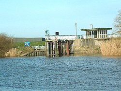
River Derwent, Yorkshire
The Derwent is a river in Yorkshire in the north of England.
It flows from Fylingdales Moor in the North York Moors National Park, east then southwards as far as its confluence with the River Hertford then westwards through the Vale of Pickering, south through Kirkham Gorge and the Vale of York, joining the River Ouse at Barmby on the Marsh. The confluence is unusual in that the Derwent converges on the Ouse at a shallow angle in an upstream direction.
The river used to flow further east, its old course entering the Ouse east of Howden.
The River Derwent catchment area includes the Upper Derwent, River Rye, River Hertford, Bielby Beck and Pocklington Canal and their tributaries. It covers an area of 2,057 square kilometres and includes the towns of Stamford Bridge, Malton, Pickering, Helmsley, Filey and Scarborough. The area is bounded by the Cleveland Hills, North York Moors and Hambleton Hills to the north, the Yorkshire Wolds and the coast to the east, the Vale of York to the west and the River Ouse and Humber Estuary to the south. The area around the river is primarily rural in nature with grazing moorland in the upland areas and a variety of agricultural uses at lower levels. There are large areas of designated conservation sites throughout the area. There are two titles named after the River Derwent in the British peerage, Viscount FitzAlan of Derwent which is extinct and Baron Derwent.