
 English
 Français

Chester-le-Street
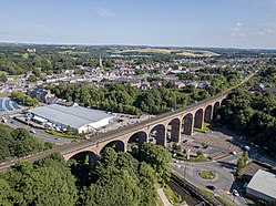
Chester-le-Street est une ville du Durham située sur la Wear, à environ 11 km au sud de Newcastle. Elle comptait 23 946 habitants au moment du recensement de 2001. En 883, des moines de l'abbaye de Lindisfarne qui fuient les Danois s'arrêtent à Chester-le-Street et y construisent une église dédiée à saint Cuthbert. L'évêque de Lindisfarne y réside pendant plus d'un siècle, avant d'aller s'installer à Durham en 995. Durant cette période, Chester-le-Street est un centre culturel actif : c'est notamment là que la glose en vieil anglais des Évangiles de Lindisfarne est réalisée. En 1974, Chester-le-Street devient le siège d'un district non-métropolitain, aboli en 2009. Elle relève depuis de l'autorité unitaire du comté de Durham.
Nearby Places View Menu
0 m
Chester-le-Street
Chester-le-Street () is a market town in County Durham, England. It is located around 6 miles (10 kilometres) north of Durham and is close to Newcastle. The town holds markets on Saturdays. In 2021, the town had a population of 23,555.
The town's history is ancient; records date to a Roman-built fort called Concangis. The Roman fort is the Chester (from the Latin castra) of the town's name; the Street refers to the paved Roman road that ran north–south through the town. The parish church of St Mary and St Cuthbert is where the body of St Cuthbert remained for 112 years (from 883 to 995 AD), before being transferred to Durham Cathedral.
An Old English translation of the Gospels was made in the 10th century: a word-for-word gloss of the Latin Vulgate text, inserted between the lines by Aldred the Scribe, who was Provost of Chester-le-Street.
271 m
Chester-le-Street Rural District
Chester-le-Street was a rural district in County Durham, England from 1894 to 1974. [1] It surrounded the urban district of Chester-le-Street.
The district was split in 1974, under the Local Government Act 1972, with the bulk going to the new Chester-le-Street district. Part of the parishes of Birtley, Harraton and South Biddick went to the Metropolitan Borough of Sunderland, in Tyne and Wear, and Lamesley and the rest of Birtley parish went to the Metropolitan Borough of Gateshead.

271 m
Chester-le-Street (district)
Chester-le-Street was a local government district in County Durham, England. Its council was based in Chester-le-Street. Other places in the district included Great Lumley and Sacriston.

277 m
Cong Burn
The Cong Burn, also referred to as the Chester Burn, is a small river in County Durham, England. It has its origin in a number of streams, among them Wheatley Green Burn, that rise on the southern and eastern slopes of Wheatley Hill, north of the village of Burnhope, and other streams, principally Whiteside Burn, that have their source on the southern slopes of Wheatley Hill and the northern slopes of Taylor's Hill, just east of Burnhope.
These streams come together in the vicinity of West Edmondsley to form the Cong Burn, which flows in a broadly easterly or northeasterly direction, around the northern flank of Waldridge Fell and the western edge of Chester-le-Street, before flowing through the town to join the River Wear immediately east of the town.
In 1932, the lower reach of the burn, where it passes through the centre of Chester-le-Street, was channelled into a covered concrete culvert, which passes beneath the town's Market Place.

347 m
Concangis
Concangis was an auxiliary castra in the Roman province of Lower Britain (Britannia Inferior). Its ruins are located in Chester-le-Street, County Durham, in England, and are now known as Chester-le-Street Roman Fort. It is situated 6 miles (10 km) north of the city of Durham and 8 miles (13 km) south of Newcastle upon Tyne.