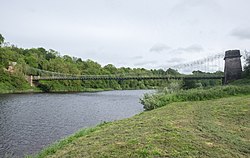
Paxton is a small village near the B6461 and the B6460, in the pre-1975 ancient county of Berwickshire, now an administrative area of the Borders region of Scotland. It lies one mile west of the border with Northumberland. It is a traditional, country village surrounded by farmland, and its closest market towns are Duns and Berwick-upon-Tweed. Paxton is beside the River Tweed which is the border at that point and on Whiteadder Water. Paxton is also the location of Paxton House. Linking Scotland and England, the nearby Union Chain Bridge, opened in 1820, was the longest wrought iron suspension bridge in the world. It was also the first of its kind in Britain.

1. History

Traditionally home to villagers working on the land or in the salmon fishery on the Tweed, Paxton is said to be the birthplace of the song Robin Adair: Paxton's a fine snug place, Robin Adair, It's a wondrous couthie place, Robin Adair; Let Whiteadder rin a spate, Or the wind blow at ony rate, Yet I'll meet thee on the gait, Robin Adair. The settlement at Paxton was burnt by an English army in November 1542.

1. See also

Paxton House

1. References


1. External links

CANMORE/RCAHMS record for Paxton, Village Hall CANMORE/RCAHMS record for Paxton, General SCRAN image: Salmon Fishers Hauling In Their Catch At Paxton On The River Tweed GEOGRAPH image: Church of Scotland, Paxton Paxton Village Hall official website

Nearby Places View Menu
Location Image
679 m

Edrington

Edrington is a medieval estate occupying the lower part of Mordington parish in Berwickshire, Scotland, five miles (8.0 km) west of Berwick-upon-Tweed. From probably the 14th century, if not earlier, a castle occupied the steep hill above the mill of the same name on the Whiteadder Water. The castle ruin is still marked on today's Ordnance Survey maps, and still appears in locality references in The Berwickshire News. The principal farm of the estate is Edrington Mains.
Location Image
1.0 km

Paxton House, Berwickshire

Paxton House is a historic house at Paxton, Berwickshire, in the Scottish Borders, a few miles south-west of Berwick-upon-Tweed, overlooking the River Tweed. It is a country house built for Patrick Home of Billie in an unsuccessful attempt to woo a Prussian heiress, Sophie de Brandt. Attributed to James Adam (possibly in concert with John Adam), it was built between 1758 and 1766, under the supervision of James Nisbet, with extensive interiors (c1773) by Robert Adam, as well as furniture by Thomas Chippendale. The East Wing was added in 1812-13 by architect Robert Reid to house the library and picture gallery. Other inhabitants were Alexander Home and his son George Home (of Wedderburn and Paxton). In 1852 Jean Milne, the wife of David Milne, inherited the house and he renamed himself David Milne-Home. Formerly the seat of the Paxton family, who became Forman-Home, Milne-Home, and finally Home-Robertson as the direct male lines failed and the inheritance progressed through a female. In 1988, the last laird, John David Home Robertson, a Labour member of Parliament, placed the house and grounds into the Paxton House Historic Building Preservation Trust. It is now open to the public and is a Partner Gallery of National Galleries Scotland.
Location Image
1.9 km

Union Chain Bridge

The Union Chain Bridge or Union Bridge is a suspension bridge that spans the River Tweed between Horncliffe, Northumberland, England and Fishwick, Berwickshire, Scotland. It is four miles (6.4 km) upstream of Berwick-upon-Tweed. When it opened in 1820 it was the longest wrought iron suspension bridge in the world with a span of 449 feet (137 m), and the first vehicular bridge of its type in the United Kingdom. Although work started on the Menai Suspension Bridge earlier, the Union Bridge was completed first. The suspension bridge, which is a Category A listed building in Scotland, is now the oldest to be still carrying road traffic. The bridge is also a Grade I listed building in England and an International Historic Civil Engineering Landmark. It lies on Sustrans Route 1 and the Pennine Cycleway. Its chains are represented on the Flag of Berwickshire.
Location Image
2.1 km

Low Cocklaw

Low Cocklaw is a small hamlet about 3 miles (5 km) west of Berwick-upon-Tweed, England. Until the early 1980s it was a working farm but is now entirely residential. It is surrounded by rolling farmland which is dominated by cereal growing.