English
 Français

Fort romain de Carrawburgh
Carrawburgh était une colonie romaine du Northumberland en Angleterre. À l'époque romaine, c'était le site d'un fort auxiliaire de 1,5 ha situé entre les forts de Cilurnum et Vercovicium du mur d'Hadrien appelé Brocolitia, Procolita ou Brocolita. Le nom Procolita apparaît dans la Notitia dignitatum, un document du Ve siècle, et Brocoliti dans la Cosmographie de Ravenne du VIIe siècle. Ce nom est probablement basé sur le nom celtique du lieu, et une traduction possible est « trou de blaireau ».
1. Historique
Le fort auxiliaire romain de Brocolitia faisait partie de la chaîne de 16 forts fortifiés le long du mur d'Hadrien (per lineam valli) et en assurait la sécurité dans sa partie orientale. Le fort se trouvait à environ un mile à l'ouest du point le plus septentrional du mur, à Limestone Corner (en), et à un peu plus d'un mile à l'ouest du milecastle (petite fortification rectangulaire) le plus proche, le Milecastle 30 (en). Brocolitia fut utilisé par l'armée romaine pendant environ 300 ans. Le vicus (établissement civil) se trouvait juste à l'extérieur du côté ouest du fort et couvrait environ 4 ha.
1. Description
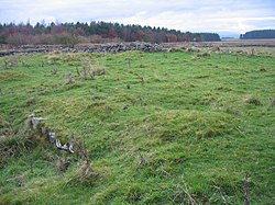
Seuls les terrassements du fort sont aujourd'hui visibles, le mur à cet endroit et les remparts nord ayant été démolis pour la construction de la route militaire du général George Wade au début du XVIIIe siècle (aujourd'hui la B6318 (en)). L'archéologue John Clayton (en), à la fin du XIXe siècle, a effectué une fouille partielle du site, révélant des thermes militaires à l'extérieur de la porte ouest du fort (en 1873) et la tour d'angle sud-ouest du fort (en 1876). Au delà de l'angle sud-ouest du fort se trouvent les vestiges d'un petit sanctuaire romain, dit puits de coventina, dédié à la déesse britto-romaine Coventina.
À environ 80 m du coin sud se trouvent les ruines d'un mithraeum du début du IIIe siècle, c'est-à-dire un temple du culte à mystères du dieu romain Mithra.
Les Roman Inscriptions of Britain recensent 48 inscriptions pour le site. Elles indiquent les unités de garnison suivantes :
Cohors I Tungrorum 122-138 apr. J.-C., plus tard à Vercovicium Cohors prima Aquitanorum 133 apr. J.-C. Cohors I Cugernorum, fin IIe siècle Cohors Batavorum 213-222, 237 et 400 apr. J.-C. respectivement La première cohorte romaine de Frisiavons est également attestée à Brocolitia à un moment donné, comme le montre une inscription sur une pierre d'autel, qui nous dit que l'Optio Maus avait remboursé un vœu à la déesse Coventina. (Cette unité est également enregistrée comme présente à Ardotalia (en). On ne sait pas si cet autel était le remboursement du vœu.
1. Galerie


1. Voir aussi


1. = Références =


1. = Bibliographie =
(en) David J. Breeze 1972 Excavations at the Roman fort of Carrawburgh, 1967–1969, Archaeologia Aeliana or miscellaneous tracts relating to antiquity, Third series Band 1 (1904)- 21 (1924) 50. (en) J. H. Corbitt: The Goddess Coventina and her Well at Carrawburgh. In: Northumberland Archaeology News. 6 (5) 1958. (en) I. A. Richmond, J. P. Gillam: The Temple of Mithras at Carrawburgh. Archaeol. Aeliana. Nr. 4 XXIX, the excavation report 1951. (en) John Clayton, Charles Roach Smith: The Temple of the Goddess Coventina. At Brocolitia, Northumberland 1878. (englisch; Taschenbuch: Kessinger Publishing, 2010 (ISBN 978-1-167-16901-4). (en) Guy de la Bédoyère: Hadrian’s Wall: history and guide. Tempus, 1998 (ISBN 0-7524-1407-0). (en) Lindsay Allason-Jones, Bruce McKay: Coventina’s Well. Oxbow Books, Oxford 1985.
1. = Articles connexes =
Mur d'Hadrien Forts et autres structures du mur d'Hadrien
1. = Liens externes =
(en) « Ropman Britain », sur roman-britain.co.uk (en) « Carrawburgh », sur romaninscriptionsofbritain.org
Portail de la Rome antique Portail de l’Angleterre
Nearby Places View Menu

Carrawburgh

Milecastle 31

Greenhaugh
Milecastle 32