
 English
 Français

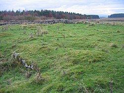
Milecastle 31
Milecastle 31 (Carrawburgh) was a milecastle of the Roman Hadrian's Wall. Its remains exist as a turf covered platform beside (and partially covered by) the B6318 Military Road, just to the east of Carrawburgh fort (adjoining the car park).
Nearby Places View Menu

336 m
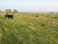
Carrawburgh
Carrawburgh is a settlement in Northumberland. In Roman times, it was the site of a 3+1⁄2-acre (1.5 ha) auxiliary fort on Hadrian's Wall called Brocolitia, Procolita, or Brocolita.
The name "Procolita" is found in the 5th-century document, the Notitia Dignitatum, and "Brocoliti" in the 7th-century Ravenna Cosmography. The name is probably based on the Celtic name for the place, and one possible translation put forward is 'badger holes'.
980 m
Milecastle 32
Milecastle 32 (Carraw) was a milecastle of the Roman Hadrian's Wall. Its remains exist as earthworks and with no exposed masonry. The layout of the milecastle walls is defined (still quite evident) by robber trenches (to a maximum depth of 0.3 metres (1 ft 0 in). The north wall is beneath a modern wall.

1.3 km
Greenhaugh
Greenhaugh is a small village in Northumberland, England. It is located northwest of Bellingham and borders the Northumberland National Park. It is in the parish of Tarset.
2.0 km
Milecastle 30
Milecastle 30 (Limestone Corner) was a milecastle of the Roman Hadrian's Wall. Its remains exist as an outward-facing scarp with a maximum height of 0.8 metres (2.6 ft). Masonry from the east wall (both faces) remains in situ. The remaining stretch is 3.1 metres (10 ft) in length by 2.25 metres (7.4 ft) thick, and survives to a height of 0.6 metres (2.0 ft). It is located at the western part of Limestone Corner, just off the B6318 Military Road.