
 English
 Français
Haverthwaite
Haverthwaite est un village et une paroisse civile de Cumbria, situé dans le nord-ouest de l'Angleterre.
Nearby Places View Menu

0 m
Haverthwaite
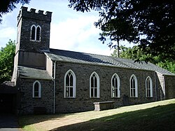
Haverthwaite is a small village and civil parish in the Furness region of Cumbria, England. It is also within the boundaries of the Lake District National Park. The village is 7 km or 4.5 miles NE of Ulverston and 5 km or 3 miles SW of the southern end of Windermere. It is near the tidal limit of the River Leven. In the 2001 census, the parish had a population of 728, which increased to 797 by 2011.

677 m
A590 road
The A590 is a trunk road in southern Cumbria, in the north-west of England. It runs north-east to south-west from M6 junction 36, through the towns of Ulverston and Barrow-in-Furness to terminate at Biggar Bank on Walney Island. The road is a mixture of dual carriageway and single carriageway, with the section east of Low Newton, Cumbria to the M6 being mainly dual. Further dual sections are south of Newby Bridge, south of Greenodd and south of Ulverston. The road is the main route for tourists entering the southern Lake District. It has often humorously been described as "the longest cul-de-sac in the world".

773 m
Haverthwaite railway station
Haverthwaite railway station is the western terminus of the preserved Lakeside and Haverthwaite Railway; it serves the village of Haverthwaite, in Cumbria, England.

1.0 km
Bigland Tarn
Bigland Tarn is a lake in Cumbria, England, about 3/4 mile southeast of Haverthwaite. Located at an elevation of 158 m (518 ft), the lake has an area of 5.1 hectares (13 acres) and measures 325 m × 225 m (1,066 ft × 738 ft).

1.7 km
Backbarrow
Backbarrow is a village in the Lake District National Park in England. It lies on the River Leven about 5 miles (8 km) northeast of Ulverston in Furness in the county of Cumbria.