
 English
 Français

Madina Masjid & Islamic Centre
Madina Masjid & Islamic Centre (MMIC) (Bengali: মদিনা মসজিদ ও ইসলামিক সেন্টার) is a mosque in Oldham, United Kingdom. It was established in 1987, making it one of the oldest mosques in the area.
Nearby Places View Menu

243 m
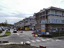
Coldhurst
Coldhurst (or more rarely Cold Hurst) is an area of Oldham and an electoral ward of the wider Metropolitan Borough of Oldham in Greater Manchester, England. At the time of the United Kingdom Census 2001, it had a population of 11,935, increasing to 13,201 at the 2011 Census. The electoral ward spans most of Oldham's town centre, although the name Coldhurst conventionally applies to the area immediately north of the centre. The district of Westwood and a small adjoining part of Chadderton in the Busk area also lie within the Coldhurst ward district.
Historically a part of Lancashire, Coldhurst was formerly a chapelry within the ancient ecclesiastical parish of Prestwich-cum-Oldham, in the Salfordshire hundred.
An old hall existed in the locality belonging to Abram Crompton Esq, which gave its name to Crompton Street.
Coldhurst is said to have been the scene of an action in the English Civil War in which the parliamentarians were defeated.
Following the Industrial Revolution, Coldhurst was the site of considerable industry and commerce, including coal mining, cotton spinning and hat manufacture.
Coldhurst is the home of a significant community of South Asian (particularly Bangladeshi) heritage. 37% of the population is non-white and most of the white residents live in what have been described as "bleak council developments". In 2001, Coldhurst was in the 5% most deprived wards in the United Kingdom.
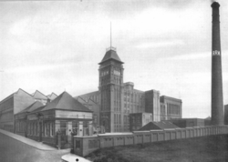
A photograph of Coldhurst during the Victorian era was used as part of the "Made of Manchester" promotion of the home strip worn by Manchester United F.C. for the 2012–13 season.
352 m
Royal Oldham Hospital
The Royal Oldham Hospital is a NHS hospital in the Coldhurst area of Oldham, Greater Manchester, England. It is managed by the Northern Care Alliance NHS Foundation Trust. The hospital has its own volunteer-run radio station, Radio Cavell, which broadcasts at 1350 AM.

530 m
Westwood, Greater Manchester
Westwood is an urban area of Oldham, in Greater Manchester, England. It occupies a hillside known as North Moor in the western part of Oldham, close to its boundary with Royton and Chadderton. Westwood, which has no formal boundary or extent, is bisected by the A6048 road .
Historically a part of Lancashire, Westwood was formerly an electoral ward of the County Borough of Oldham, but is now split between the wards of Coldhurst and Werneth, which lie to the north and south respectively. Apart from its industrial and commercial units, Westwood's built environment is "almost entirely" composed of Victorian era terraces, with some small pockets of housing association and council house properties.
The Metropolitan Borough of Oldham has the largest population of Bangladeshis in the United Kingdom outside of London. Sixty percent of the borough's Bangladeshi community live in Westwood. Most of them immigrated from the Sylhet Division of Bangladesh.
Westwood features a replica of the Shaheed Minar national monument, which commemorates those killed in the Bengali language movement demonstrations in 1952.
In the 1980s, unemployment in Westwood experienced a "massive increase", significantly higher than the "modest increase" seen in Oldham as a whole. Ethnicity was attributed as a factor.
Westwood Moravian Church congregation was founded in 1865. A church building for the congregation dating from 1869 still stands in the locality. The congregation now worships in Royton.
Winston Churchill frequented Westwood's Conservative club. Churchill orated at the club during his period as Member of Parliament for Oldham.
Westwood Primary is a primary school located in the area.
Westwood Metrolink station opened in 2012 in Phase 3b of the Manchester Metrolink extension. It was funded by the Greater Manchester Transport Innovation Fund.
The Greater Manchester Waste Disposal Authority operate a transfer loading station at Westwood Industrial Estate. Anchor Retail Park occupies Anchor Mill, a former cotton mill.
581 m
Royton Ring Mill, Royton
Royton Ring Mill was a cotton mill in Royton, Greater Manchester, England. It was built in 1908 and extended in 1912. It was taken over by the Lancashire Cotton Corporation in 1935 and passed to Courtaulds in 1964. Production finished in 1966. It was extended again in 1969 and used for other purposes. It has now been demolished, the street has been renamed and houses have replaced it.