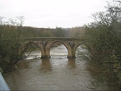
Chester New Bridge is a Grade II* listed medieval stone bridge over the River Wear near Chester-le-Street in County Durham, England. It carries Black Drive, the private entrance road to Lambton Castle, across the Wear just north of the A1052 road bridge, which superseded it in 1926. Frank Graham in Bridges of Northumberland and Durham describes it as "a fine 14th century bridge" but the official English Heritage listing citation considers it to be "probably C15". The parapet, which English Heritage suggest may be partly rebuilt, bears a worn inscription referring to "Charles Swinburne's Leap", an incident in which a horse and its rider were killed falling from the bridge. The bridge has a span of approximately 45 metres (148 ft) and four pointed arches with cutwaters on each pier. An archway at its eastern end, erected in 1815 by Ignatius Bonomi, marks the entrance to the Lambton Estate.

Nearby Places View Menu
Location Image
865 m

Cong Burn

The Cong Burn, also referred to as the Chester Burn, is a small river in County Durham, England. It has its origin in a number of streams, among them Wheatley Green Burn, that rise on the southern and eastern slopes of Wheatley Hill, north of the village of Burnhope, and other streams, principally Whiteside Burn, that have their source on the southern slopes of Wheatley Hill and the northern slopes of Taylor's Hill, just east of Burnhope. These streams come together in the vicinity of West Edmondsley to form the Cong Burn, which flows in a broadly easterly or northeasterly direction, around the northern flank of Waldridge Fell and the western edge of Chester-le-Street, before flowing through the town to join the River Wear immediately east of the town. In 1932, the lower reach of the burn, where it passes through the centre of Chester-le-Street, was channelled into a covered concrete culvert, which passes beneath the town's Market Place.
Location Image
936 m

Chester-le-Street

Chester-le-Street () is a market town in County Durham, England. It is located around 6 miles (10 kilometres) north of Durham and is close to Newcastle. The town holds markets on Saturdays. In 2021, the town had a population of 23,555. The town's history is ancient; records date to a Roman-built fort called Concangis. The Roman fort is the Chester (from the Latin castra) of the town's name; the Street refers to the paved Roman road that ran north–south through the town. The parish church of St Mary and St Cuthbert is where the body of St Cuthbert remained for 112 years (from 883 to 995 AD), before being transferred to Durham Cathedral. An Old English translation of the Gospels was made in the 10th century: a word-for-word gloss of the Latin Vulgate text, inserted between the lines by Aldred the Scribe, who was Provost of Chester-le-Street.
Location Image
1.1 km

Lumley Park Burn

The Lumley Park Burn is a small river between County Durham and Tyne and Wear that is a tributary of the River Wear and flows by Lumley Castle. Its length is around 12.5km (7.8mi).
1.1 km

Chester-le-Street Rural District

Chester-le-Street was a rural district in County Durham, England from 1894 to 1974. [1] It surrounded the urban district of Chester-le-Street. The district was split in 1974, under the Local Government Act 1972, with the bulk going to the new Chester-le-Street district. Part of the parishes of Birtley, Harraton and South Biddick went to the Metropolitan Borough of Sunderland, in Tyne and Wear, and Lamesley and the rest of Birtley parish went to the Metropolitan Borough of Gateshead.