


The Casque du Marboré, or Casque de Gavarnie or simply le Casque, is a Pyrenean summit, culminating at 3,006 m (9,862 ft), located on the crest of three-thousanders in the Monte Perdido Range above Cirque de Gavarnie on the Franco-Spanish border.
Gallery


Sponsored
Location

435 m
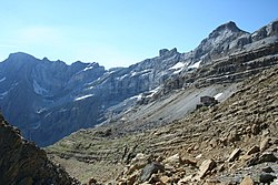
Cilindro de Marboré is a mountain in the Monte Perdido massif in the Pyrenees.
It is one of the three mountains comprising Las Tres Sorores, the others being Monte Perdido and Soum de Ramond.
It is the northernmost point of Spain crossed by the IERS Reference Meridian.

820 m
Tour du Marboré or Tour de Gavarnie is a Pyrenean summit, culminating at 3,009 m, located on the Franco-Spanish border crest in the Monte Perdido Range.

1.3 km
Marboré Peak is a summit in the Pyrenees located on the Franco-Spanish border crest in the Monte Perdido Range.
2.0 km
The Cascade Peaks are three summits in the Monte Perdido Range of the Pyrenees, culminating at 3,161 m on the eastern peak. The central peak, known as Brulle, and the western peak are 3,106 m and 3,095 m high, respectively. The peaks are located on the 3,000 m French-Spanish borderline crest.

2.1 km
Pic du Taillon or Pico Taillón is a summit in the Pyrenees, culminating at 3,144 m on the Franco-Spanish border in the Monte Perdido Range.
Pic du Taillon is considered one of the easiest 3,000ers above the Cirque de Gavarnie. Only the last part from the "finger" of the False Defile is a little steep, but the climb never technically difficult in the absence of snow. The panorama from the summit is grandiose, offering a view of the Monte Perdido Range, the Vignemale Range, the Néouvielle Range, Balaïtous and Pic du Midi de Bigorre on a clear day.