


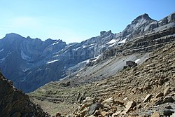
Marboré Peak (Pic de Marboré, El Marboré) is a summit in the Pyrenees located on the Franco-Spanish border crest in the Monte Perdido Range.
Gallery


Sponsored
Location
1 explorer visited this place

923 m
Tour du Marboré or Tour de Gavarnie is a Pyrenean summit, culminating at 3,009 m, located on the Franco-Spanish border crest in the Monte Perdido Range.
1.0 km
The Cascade Peaks are three summits in the Monte Perdido Range of the Pyrenees, culminating at 3,161 m on the eastern peak. The central peak, known as Brulle, and the western peak are 3,106 m and 3,095 m high, respectively. The peaks are located on the 3,000 m French-Spanish borderline crest.

1.2 km
The Pyrénées – Mont Perdu World Heritage Site is a World Heritage Site straddling the border between Spain and France in the Pyrenees mountain chain. The summit of Monte Perdido is on the Spanish side of the border. The site was designated in 1997 and extended north in 1999 to include the Commune of Gèdre in France.
The site includes two bordering national parks: the entire Ordesa y Monte Perdido National Park in Spain and the eastern part of Pyrénées Occidentales National Park in France.
The World Heritage Site comprises a total area of 30,639 hectares.
1.3 km
Épaule du Marboré is a pyrenean summit, culminating at 3,073 m in the Monte Perdido Range, marking the Franco-Spanish border. It lies on the Greenwich meridien.

1.3 km
Cilindro de Marboré is a mountain in the Monte Perdido massif in the Pyrenees.
It is one of the three mountains comprising Las Tres Sorores, the others being Monte Perdido and Soum de Ramond.
It is the northernmost point of Spain crossed by the IERS Reference Meridian.
