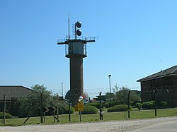
RRH Staxton Wold est une station radar de la Royal Air Force située vers Scarborough dans le North Yorkshire, en Angleterre. Le site actuel dispose d'une fonction d'alerte précoce depuis le IIIe siècle, il était alors le site d'une balise d'avertissement. Il a été sélectionné pour accueillir une station radar en 1937; les travaux de construction n'ont commencé qu'en décembre 1938, des retards dans l'acquisition du site ayant eu lieu lorsque les propriétaires ont résisté à la vente (l'achat ayant lieu avant la seconde guerre mondiale, le gouvernement a eu plus de mal à invoquer l'effort de guerre pour se porter acquéreur des terrains). Le site est devenu pleinement opérationnel en avril 1939, il est maintenant le seul des postes originaux encore en service. Il pourrait donc s’agir de la plus ancienne station radar toujours en activité. Aujourd'hui, le site est intégré au sein du système de surveillance et de contrôle de l'air du Royaume-Uni (UKASACS). Le radar de Staxton Wold est aujourd'hui un Lockheed Martin TPS77 qui devait fonctionner dès septembre 2013, mais qui ne fut pleinement opérationnel qu'à partir de 2015. En septembre 2017, le radar AN/TPS-77 basé à Staxton Wold aurait été transféré au RRH Saxa Vord.

1. Voir aussi

Bases aériennes de la Royal Air Force

1. Notes et références

(anglais) Cet article est partiellement ou en totalité issu de l’article de Wikipédia en anglais intitulé « RRH Staxton Wold » (voir la liste des auteurs).

1. Liens externes

RRH Staxton Wold. « RRH Staxton Wold », sur zone-interdite.net via Wikiwix (consulté le 22 avril 2024). Portail de l’histoire militaire Portail de l’Angleterre Portail de la Royal Air Force

Nearby Places View Menu
Location Image
0 m

RRH Staxton Wold

Remote Radar Head Staxton Wold or RRH Staxton Wold is an air defence radar station operated by the Royal Air Force, located near Scarborough in North Yorkshire, England. As it has been a radar site continuously since 1939, it has a claim to be the oldest working radar station in the world. the base has undergone many upgrades of different radar systems and sits on the top of Staxton Wold at a height of 590 feet (180 m) above sea level.
1.3 km

Sherburn Rural District

Sherburn was a rural district in the East Riding of Yorkshire from 1894 to 1935. It was formed under the Local Government Act 1894 from that part of the Scarborough rural sanitary district which was in the East Riding (the rest forming Scarborough Rural District in the North Riding). It was abolished in 1935 by a County Review Order made under the Local Government Act 1929 and transferred to Norton Rural District, Bridlington Rural District and a small part to Filey Urban District.
1.5 km

Staxton

Staxton is a village in North Yorkshire, England, part of the civil parish of Willerby, and situated approximately 8.2 miles from Scarborough town centre. Until 1974 the village lay in the historic county boundaries of the East Riding of Yorkshire. From 1974 to 2023 it was part of the district of Ryedale, it is now administered by the unitary North Yorkshire Council.
Location Image
1.5 km

Willerby, North Yorkshire

Willerby is a small village and civil parish in North Yorkshire, England. It is contiguous with neighbouring Staxton. The villages of Staxton, Willerby and Binnington make up the civil parish of Willerby. Until 1974 the village lay in the historic county boundaries of the East Riding of Yorkshire. Between 1974 and 2023 the parish was part of the district of Ryedale. It is now administered by North Yorkshire Council. According to the 2001 UK census, Willerby parish had a population of 708, increasing to 737 at the 2011 census.
Location Image
1.5 km

Binnington Carr Hoard

The Binnington Carr Hoard is a Roman coin hoard dating from the late 1st century AD. It contains 12 silver denarii within a copper alloy bell. It is in the collection of the Yorkshire Museum.