
 English
 Français

Baddington
Baddington est un village anglais située dans le comté de Cheshire sur le Shropshire Union Canal.
Nearby Places View Menu

681 m
Baddington
Baddington is a civil parish in the unitary authority of Cheshire East and the ceremonial county of Cheshire, England, which lies immediately to the south-west of Nantwich and north of Audlem. Predominantly rural with scattered farms, the civil parish has a total population of around 100 people, increasing to 212 at the 2011 Census, and includes the dispersed settlement of Hack Green, the site of a former RAF decoy station, radar station and Home Defence regional headquarters. Nearby villages include Aston, Broomhall Green, Hankelow, Ravensmoor, Sound Heath and Stapeley.
1.6 km
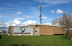
Hack Green Secret Nuclear Bunker
The Hack Green Secret Nuclear Bunker is a former government-owned nuclear bunker located at Hack Green, Cheshire, England.

1.7 km
Sound, Cheshire
Sound is a hamlet (at SJ619483) and civil parish in the unitary authority of Cheshire East and the ceremonial county of Cheshire, England. The hamlet is located 3+1⁄4 miles (5.2 km) to the south west of Nantwich. The civil parish covers 1,089 acres (441 ha) and also includes the small settlements of Newtown and Sound Heath, with a total population at the 2011 census of 239. Nearby villages include Aston, Ravensmoor and Wrenbury.
The name is of Saxon origin and means "a sandy place". The first record of the township is in 1310. It was raided by Royalist forces in 1643, during the Civil War. The Methodist chapel was built in 1838, and a primary school on the boundary with Broomhall opened in 1876. Other historic buildings include a rare example of a malt kiln.
The River Weaver runs along the southern boundary and the Welsh Marches railway line crosses the parish. The area is mainly agricultural, with dairy farming predominating. The flat terrain has an average elevation of around 60 metres. There is a small Site of Special Scientific Interest and Local Nature Reserve named Sound Heath, which forms an important habitat for freshwater invertebrates and breeding birds. Nationally scarce species observed here include the mud snail, great raft spider, a species of water scavenger beetle and the beautiful snout moth.

1.7 km
Edleston
Edleston is a former civil parish, now in the parishes of Burland and Acton and Nantwich, in the unitary authority area of Cheshire East and the ceremonial county of Cheshire, England, which lies immediately to the south west of Nantwich. For administrative purposes, it was combined with adjacent civil parishes of Acton and Henhull to form a total area of 765 hectares (1890 acres). The parish was predominantly rural with scattered farms and houses, with the exception of a new housing estate at the eastern end of the parish east of the canal. Nearby villages include Acton and Ravensmoor.
According to the 2001 census, the parish had a population of 53. Since then new building in the parish has increased the population, with over 300 new houses in the east of the parish bringing the population to well over 500. Malbank Waters is a two-phase development of nearly 400 houses in the east of Edleston as an extension to the town of Nantwich. The first phase was completed in January 2019.

1.7 km
Broomhall, Cheshire
Broomhall is a civil parish in the unitary authority of Cheshire East and the ceremonial county of Cheshire, England. The main line of the Shropshire Union Canal runs through the parish and the River Weaver forms part of its boundary. The main settlement is the hamlet of Broomhall Green, which lies on the A530 about 3.5 miles (5.6 km) south-west of Nantwich. The civil parish has an area of 539 hectares (1,330 acres), and also includes part of the small settlement of Sandford (also in Newhall parish), with a total population of around 200 in 2011. Nearby villages include Aston, Sound, Wrenbury and Audlem. Broomhall appears in the Domesday survey and the name was also historically spelled Bromhall.