
 English
 Français

Baddington
Baddington is a civil parish in the unitary authority of Cheshire East and the ceremonial county of Cheshire, England, which lies immediately to the south-west of Nantwich and north of Audlem. Predominantly rural with scattered farms, the civil parish has a total population of around 100 people, increasing to 212 at the 2011 Census, and includes the dispersed settlement of Hack Green, the site of a former RAF decoy station, radar station and Home Defence regional headquarters. Nearby villages include Aston, Broomhall Green, Hankelow, Ravensmoor, Sound Heath and Stapeley.
Nearby Places View Menu

1.1 km
Edleston
Edleston is a former civil parish, now in the parishes of Burland and Acton and Nantwich, in the unitary authority area of Cheshire East and the ceremonial county of Cheshire, England, which lies immediately to the south west of Nantwich. For administrative purposes, it was combined with adjacent civil parishes of Acton and Henhull to form a total area of 765 hectares (1890 acres). The parish was predominantly rural with scattered farms and houses, with the exception of a new housing estate at the eastern end of the parish east of the canal. Nearby villages include Acton and Ravensmoor.
According to the 2001 census, the parish had a population of 53. Since then new building in the parish has increased the population, with over 300 new houses in the east of the parish bringing the population to well over 500. Malbank Waters is a two-phase development of nearly 400 houses in the east of Edleston as an extension to the town of Nantwich. The first phase was completed in January 2019.

1.8 km
Austerson
Austerson is a civil parish in the unitary authority of Cheshire East and the ceremonial county of Cheshire, England, lying immediately south of the town of Nantwich and north of the village of Audlem. Predominantly rural with scattered farms, the civil parish includes the small settlement of Old Hall Austerson at SJ656493, about two miles south of Nantwich centre. In 2001, the total population was a little under 150, increasing to 194 at the 2011 Census. Nearby villages include Broomhall Green, Hack Green, Hankelow, Sound Heath and Stapeley.

1.8 km
Ravensmoor
Ravensmoor is a village in the unitary authority of Cheshire East and the ceremonial county of Cheshire, England, located at SJ620505. It is split between the civil parishes of Baddiley and Burland and Acton. It lies at an elevation of 65 m, around 2+1⁄4 miles (3.6 km) south west of Nantwich and 6 miles (9.7 km) south west of Crewe.
The village centres on the crossroads of Baddiley Lane, Marsh Lane, Swanley Lane and Sound Lane, with a small village green adjacent. Much of the village dates from the second half of the 20th century.
The village lies within a fork of the Shropshire Union Canal south of the Hurleston Junction; the Llangollen branch runs 2⁄3 mile (1.1 km) to the west and the main line of the canal runs just over a mile to the east. Ravensmoor Brook runs to the east of the village and Edleston Brook to the south and west.
1.9 km
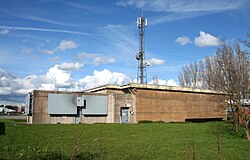
Hack Green Secret Nuclear Bunker
The Hack Green Secret Nuclear Bunker is a former government-owned nuclear bunker located at Hack Green, Cheshire, England.