
 English
 Français
Hayfield (Derbyshire)
Hayfield est une paroisse civile et un village du Derbyshire, en Angleterre.
Nearby Places View Menu
0 m
Hayfield, Derbyshire
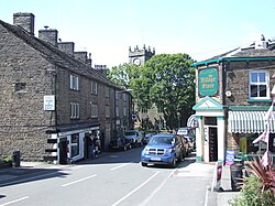
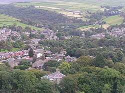
Hayfield (SK037870) is a village and civil parish in High Peak, Derbyshire, England, with a population of around 2,700. The village is 3 miles (4.8 km) east of New Mills, 4.5 miles (7.2 km) south of Glossop and 10 miles (16 km) north of Buxton, in the basin of the River Sett.
The civil parish includes Hayfield village itself, the hamlets of Little Hayfield and part of Birch Vale, and a significant proportion of the Kinder Scout plateau.

394 m
St Matthew's Church, Hayfield
St Matthew's Church, Hayfield, is the parish church of Hayfield, Derbyshire, England. The church, parts of which date from the 14th century, is a Grade II listed building and adjacent to the River Sett. Its five-stage clock tower is the main landmark for the village. The church is built in local gritstone ashlar in an Early English Gothic style and is surrounded by a small graveyard. It is also adjoined by a small church hall dating from 1977, erected over part of the graveyard, with a newly landscaped community garden on the north side of the building.
St Matthew's is an active Anglican parish church in the Diocese of Derby, arranging services on Sundays, in addition to baptisms, weddings and funerals. It is the venue for a variety of community events including concerts, art displays, and annual May Queen and well dressing festivals. The clergy is shared with the Parish of Chinley & Buxworth; the current vicar is Mel Hartley.

480 m
Hayfield railway station
Hayfield railway station was the terminus of the 3 mi (4.8 km) Hayfield branch from New Mills Central station in Derbyshire, England.

1.8 km
Birch Vale
Birch Vale is a village in the High Peak district of Derbyshire, just outside the boundary of the Peak District National Park, between New Mills and Hayfield. Most of Birch Vale, including the attached hamlet of Thornsett, comes under the administration of New Mills Town Council, though the small part to the east of the former Grouse Inn public house is within the boundaries of Hayfield.
1.8 km
Lantern Pike
Lantern Pike is a hill located just outside Hayfield, in Derbyshire, England. The land lies within the Peak District National Park and is owned and maintained by the National Trust. It is permanently open to the public. According to Ordnance Survey, it is 373 metres (1,224 ft) in height (measured by air survey).
According to the booklet 10 Walks Around Hayfield, published by the Peak District National Park Authority, the name Lantern Pike probably comes from the hill's use as a beacon.
The hill is a popular hiking destination, and is often considered a continuation of nearby Kinder Scout. The Peak District Boundary Walk runs south to north past the summit and the Pennine Bridleway crosses the eastern flank of the hill.
Lantern Pike gives its name to the Lantern Pike Inn in nearby Little Hayfield.