
 English
 Français
Frodsham
Frodsham est un bourg et une civil parish (paroisse civile) situé dans l'autorité unitaire de Cheshire West and Chester, dans le comté traditionnel de Cheshire, en Angleterre. Frodhsam se trouve à environ 5 km au sud de Runcorn, à 26 km au sud de Liverpool et à 45 km au sud-ouest de Manchester. Au recensement de 2001, le bourg comptait 8 982 habitants.
Nearby Places View Menu
130 m
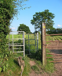
Sandstone Trail
The Sandstone Trail is a 55-kilometre (34 mi) long-distance walkers' path, following sandstone ridges running north–south from Frodsham in central Cheshire to Whitchurch just over the Shropshire border. The path was created in 1974 and extended in the 1990s. Much of the route follows the Mid Cheshire Ridge but in places the trail also passes through the Cheshire Plain, including farmland, woodland and canal towpaths.
130 m
Frodsham School
Frodsham School was a designated specialist science and technology college in the town of Frodsham, Cheshire, England. The school closed in the summer of 2009 due to declining enrollment because of lower birth rates in recent years; most of the school's intake came from the nearby Runcorn area, and there is another local high school, Helsby High School.
The school was a 12–18 co-educational Comprehensive school governed by Cheshire LEA, offering single sex and co-education with mixed age tutor groups. In its final year, the school no longer had a year seven, as the closure programme meant that no admissions at age 11 were considered in 2007.

139 m
Bear's Paw Hotel, Frodsham
The Bear's Paw Hotel is in Main Street, Frodsham, Cheshire, England. It is recorded in the National Heritage List for England as a designated Grade II listed building, and is now a public house.

173 m
Frodsham railway station
Frodsham railway station serves the town of Frodsham, Cheshire, England. The station is managed by Transport for Wales. It was opened along with the line in 1850 and the station building is recorded in the National Heritage List for England as a designated Grade II listed building. This was restored in 2012 and is in private ownership.
The station is unstaffed, however the North Cheshire Rail Users Group have "adopted" the station and work on a voluntary basis to keep it looking clean and tidy.
261 m
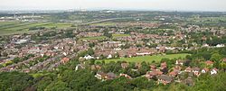
Frodsham
Frodsham is a market town, civil parish, and electoral ward in the unitary authority of Cheshire West and Chester and the ceremonial county of Cheshire, England. Its population in 2021 was 9,300. It is 14 miles (23 km) south east of Liverpool and 28 miles (45 km) southwest of Manchester. The River Weaver runs to its northeast and on the west it overlooks the estuary of the River Mersey. The A56 road and the Chester–Manchester railway line pass through the town, and the M56 motorway passes to the northwest.
In the medieval era, Frodsham was an important borough and port belonging to the Earls of Chester. Its parish church, St. Laurence's, still exhibits evidence of a building present in the 12th century in its nave and is referenced in the Domesday Book. A market is held each Thursday, and Frodsham's viability as a trading centre was emphasised by the presence of the "big five" clearing banks and several building societies, though the branches of HSBC and NatWest have recently closed. Development in the town's shops and premises with alcohol licences is evident through the opening or modernisation of contemporary-style bar, restaurants, take-aways, and public houses since 2002, and in the continued presence of small, specialised, businesses operating from town-centre shops.