
 English
 Français

Ulrome
Ulrome est une paroisse civile et un village du Yorkshire de l'Est, en Angleterre.
1. Notes et références
(en) Cet article est partiellement ou en totalité issu de l’article de Wikipédia en anglais intitulé « Ulrome » (voir la liste des auteurs).
1. Liens externes
Ressource relative à la géographie : Open Domesday
Portail du Yorkshire
Nearby Places View Menu

3 m
Ulrome
Ulrome is a village and civil parish in the East Riding of Yorkshire, England. It is situated approximately 6 miles (9.7 km) north of the town of Hornsea and on the east side of the B1242 road. The parish includes the village of Lissett. Its area is 1,139.535 hectares (2,815.85 acres), in 2011 had a population of 239, a reduction on the 2001 UK census figure of 260.
The parish church of St Andrew is a Grade II listed building.
The name Ulrome probably derives from the Old English Wulfherehām meaning 'Wulfhere's village'.
1.8 km
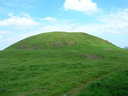
Skipsea Castle
Skipsea Castle was a Norman motte and bailey castle near the village of Skipsea, East Riding of Yorkshire, England. Built around 1086 by Drogo de la Beuvrière, apparently on the remains of an Iron Age mound, it was designed to secure the newly conquered region, defend against any potential Danish invasion and control the trade route across the region leading to the North Sea. The motte and the bailey were separated by Skipsea Mere, an artificial lake that was linked to the sea during the medieval period via a navigable channel. The village of Skipsea grew up beside the castle church, and the fortified town of Skipsea Brough was built alongside the castle around 1160 to capitalise on the potential trade.
In 1221 the castle's owner, William de Forz, the Count of Aumale, rebelled against Henry III; the fortification was captured by royalist forces and the King ordered it to be destroyed. The remains of the castle had little value by the end of the 14th century and Skipsea Brough failed to attract many inhabitants. The castle passed into the control of the state in the early 20th century and various archaeological investigations were carried out between 1987 and 2001. In the 21st century, Skipsea Castle is managed by English Heritage and open to visitors.
1.9 km
Skipsea
Skipsea is a village and civil parish on the North Sea coast of the East Riding of Yorkshire, England. It is situated approximately 10 miles (16 km) south of Bridlington and 6 miles (9.7 km) north of Hornsea on the B1242 road at its junction with the B1249 road.
The civil parish is formed by the village of Skipsea and the hamlets of Skipsea Brough and Dringhoe. According to the 2011 UK census, Skipsea parish had a population of 693, an increase on the 2001 UK census figure of 633.
From the medieval era until the 19th century Skipsea was part of Dickering Wapentake. Between 1894 and 1974 Skipsea was a part of the Bridlington Rural District, in the East Riding of Yorkshire. Between 1974 and 1996 it was part of the Borough of North Wolds (later Borough of East Yorkshire), in the county of Humberside.
Just to the west of the village, in Skipsea Brough, lies Skipsea Castle. Built in 1086, the motte-and-bailey style castle has since been destroyed; however impressive earthworks remain. The coast near Skipsea, just over 0.6 miles (1 km) to the east, is the fastest eroding coastline in northern Europe.

1.9 km
Barmston Lifeboat Station
Barmston Lifeboat Station was located near to Horse Bridge, on Southfield Lane, at the end of Barmston Main Drain, approximately 1⁄4 mile (0.40 km) to the south east of Barmston, on the coast of the East Riding of Yorkshire.
A lifeboat was first stationed at Barmston in 1884, by the Royal National Lifeboat Institution (RNLI).
Barmston lifeboat station was closed in 1898.

2.0 km
Church of All Saints, Skipsea
The Church of All Saints, is the church for the village and parish of Skipsea, in the East Riding of Yorkshire, England. The church dates back to the late 11th/early 12th century and was the religious house tied to Skipsea Castle, which lay just to the west in Skipsea Brough. A causeway, to the north of the church, used to link it with the castle motte across what was Skipsea Bail Mere. The village continued developing long after the castle had been demolished c. 1221, and the church became the house of worship for Skipsea.
The church is partly Norman, but mostly Perpendicular in its architectural style, and the tower still shows evidence of being constructed from cobbles; stones which were quarried from the beaches in Holderness. The church is now a grade I listed structure and underwent several renovations in the 19th century. All Saints is at the west end of Skipsea, on the road which connects the village with Beeford.